
Introduction
Mizoram is one of the eight sister states of the Northeast India and is known for its beautiful hill ranges, bamboo forests, strong community life and high literacy rate. It is situated in the southernmost part of Northeast India and shares international borders with Myanmar and Bangladesh that gives it strategic importance in India’s Act East Policy.
The state is home to several Mizo tribal communities who have carefully preserved their customs, traditions, language and social values over generations. Because of its peaceful environment and close-knit society, Mizoram is often called the “Land of the Hill People.”
The economy of Mizoram is mainly supported by agriculture, horticulture, bamboo-based industries, handloom, handicrafts and tourism. The scenic landscapes, colourful festivals and rich biodiversity of the state of Mizoram make it one of the most charming and distinctive states in Northeast India.
State Nickname of Mizoram
a) Land of the Hill People
b) Land of Blue Mountains
c) Bamboo State of India
Date of Formation of Mizoram
Mizoram became the 23rd State of India on 20 February 1987.
Historical Background of Mizoram
Mizoram has a fascinating history shaped by migration, colonial rule and political change. The Mizos are believed to have migrated from East and Southeast Asia between the 16th and 18th centuries, gradually settling in the hill regions that now form the state of Mizoram.
During British rule, the region was known as the Lushai Hills and it was brought under British India in the late 19th century. After India gained independence, Mizoram became a district of Assam before moving through important administrative changes in the years that followed.
Geographical Location of Mizoram
Boundaries
Strategic Location
Climate at a Glance
State Day of Mizoram
Mizoram celebrates their state day on the 20 February every year.
Capital of Mizoram
PIN Code Prefix of Mizoram
Area of Mizoram
Area-wise Rank of Mizoram
Population of Mizoram (Census 2011)
Population Rank of Mizoram
Population Density
Sex Ratio
Literacy Rate
According to the Periodic Labour Force Survey (PLFS 2023–24), Mizoram recorded the highest overall literacy rate in India at 98.2%. The literacy rate for the state's population aged 7 and above is:
Scheduled Caste and Scheduled Tribe Population
Scheduled Caste Population
Scheduled Tribe Population
Others
Mizoram has one of the highest percentages of Scheduled Tribe population among all Indian states.
Tribes of Mizoram and Their Habitat
Universities of Mizoram
|
No. |
University |
Location |
|
1 |
Mizoram University |
Aizawl |
|
2 |
National Institute of Technology (NIT Mizoram) |
Aizawl |
|
3 |
ICFAI University Mizoram |
Aizawl |
|
4 |
Mizoram State University |
Aizawl |
|
5 |
Pachhunga University College |
Aizawl |
|
6 |
Government Aizawl College |
Aizawl |
|
7 |
Regional Institute of Paramedical and Nursing Sciences |
Aizawl |
|
8 |
College of Veterinary Sciences & Animal Husbandry |
Selesih |
State Symbols of Mizoram
Religion in Mizoram
Official Language of Mizoram
Other Languages Spoken
Legislature of Mizoram
Mizoram has a unicameral legislature.
Legislative Assembly
Judicature of Mizoram
Dance Forms of Mizoram
State Song of Mizoram
Folklore of Mizoram
Number of Districts of Mizoram with Headquarters
|
No. |
District |
Headquarters |
Established |
Area (sq. km.) |
Population (2011) |
Population Density (per sq. km.) |
|
1 |
Aizawl |
Aizawl |
— |
3,577 |
4,00,309 |
110 |
|
2 |
Champhai |
Champhai |
1998 |
3,168 |
1,25,745 |
39 |
|
3 |
Hnahthial |
Hnahthial |
2019 |
1,030 |
28,468 |
27 |
|
4 |
Khawzawl |
Khawzawl |
2019 |
1,152 |
42,355 |
36 |
|
5 |
Kolasib |
Kolasib |
1998 |
1,386 |
83,955 |
61 |
|
6 |
Lawngtlai |
Lawngtlai |
— |
2,519 |
1,17,894 |
46 |
|
7 |
Lunglei |
Lunglei |
— |
4,572 |
1,61,428 |
36 |
|
8 |
Mamit |
Mamit |
1998 |
2,967 |
86,364 |
29 |
|
9 |
Siaha (Saiha) |
Siaha |
1998 |
1,414 |
56,574 |
40 |
|
10 |
Saitual |
Saitual |
2019 |
N/A |
63,685 |
N/A |
|
11 |
Serchhip |
Serchhip |
1998 |
1,424 |
64,937 |
46 |
Important District Facts
Note: Hnahthial, Khawzawl and Saitual were officially created as separate districts in 2019 from portions of existing districts. Therefore, comparable 2001 population figures are not available for these districts.
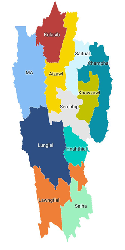
Map of Mizoram (District Map)
Number of Sub-Divisions in Mizoram
Major Sub-Divisions include:
|
No. |
District |
District Headquarters |
Key Civil Sub-Divisions within the District |
|
1 |
Aizawl |
Aizawl |
Aizawl Sadar, |
|
2 |
Lunglei |
Lunglei |
Lunglei Sadar, |
|
3 |
Siaha |
Siaha |
Siaha Sadar, |
|
4 |
Champhai |
Champhai |
Champhai Sadar, |
|
5 |
Kolasib |
Kolasib |
Kolasib Sadar, |
|
6 |
Lawngtlai |
Lawngtlai |
Lawngtlai Sadar, |
|
7 |
Mamit |
Mamit |
Mamit Sadar, |
|
8 |
Serchhip |
Serchhip |
Serchhip Sadar, |
|
9 |
Saitual |
Saitual |
Saitual Sadar, |
|
10 |
Khawzawl |
Khawzawl |
Khawzawl Sadar |
|
11 |
Hnahthial |
Hnahthial |
Hnahthial Sadar |
There are 23 sub-divisions across 11 districts of Mizoram
Number of Villages in Mizoram
Number of Blocks
Lok Sabha Seats of Mizoram
Parliamentary Constituency
Rajya Sabha Seats of Mizoram
Vidhan Sabha Seats of Mizoram
Main Towns of Mizoram
|
No. |
City/Town |
District |
Population (Census 2011) |
|
1 |
Aizawl |
Aizawl |
2,93,416 |
|
2 |
Lunglei |
Lunglei |
57,011 |
|
3 |
Champhai |
Champhai |
32,734 |
|
4 |
Saiha |
Saiha |
25,110 |
|
5 |
Kolasib |
Kolasib |
24,272 |
|
6 |
Serchhip |
Serchhip |
21,158 |
|
7 |
Lawngtlai |
Lawngtlai |
20,830 |
|
8 |
Saitual |
Aizawl* |
11,619 |
|
9 |
Khawzawl |
Champhai* |
11,022 |
|
10 |
Vairengte |
Kolasib |
10,554 |
|
11 |
Mamit |
Mamit |
7,884 |
|
12 |
N. Kawnpui |
Kolasib |
7,732 |
|
13 |
Thenzawl |
Serchhip |
7,259 |
|
14 |
Hnahthial |
Lunglei* |
7,187 |
|
15 |
Sairang |
Aizawl |
5,950 |
|
16 |
Tlabung |
Lunglei |
4,554 |
|
17 |
Bairabi |
Kolasib |
4,320 |
|
18 |
Darlawn |
Aizawl |
3,769 |
|
19 |
North Vanlaiphai |
Serchhip |
3,602 |
|
20 |
Lengpui |
Mamit |
3,282 |
|
21 |
Khawhai |
Champhai |
2,496 |
|
22 |
Biate |
Champhai |
2,277 |
|
23 |
Zawlnuam |
Mamit |
Data Not Available |
Main Crops of Mizoram
Main Cash Crops of Mizoram
Minerals Found in Mizoram
Rivers Flowing Through Mizoram
|
No. |
River Name |
Total Length (Approx.) |
Length in Mizoram (Approx.) |
Origin Point |
Confluence / Endpoint |
Key Significance & Features |
|
1 |
Tlawng (Dhaleswari) |
185 km |
185 km |
Zobawk region, Aizawl District |
Joins the Barak River in Assam |
Longest river of Mizoram, important for irrigation and water supply. |
|
2 |
Tuirial (Sonai) |
117 km |
117 km |
North of Aizawl District |
Joins the Barak River in Assam |
Site of the Tuirial Hydroelectric Project. |
|
3 |
Tuivawl |
166 km |
Major portion flows through Mizoram |
Northern hills of Mizoram |
Joins the Barak River in Assam |
Supports agriculture and local settlements. |
|
4 |
Chhimtuipui (Kolodyne) |
320 km |
About 160 km |
Myanmar Hills |
Flows into Myanmar and empties into the Bay of Bengal through the Kaladan River system |
Largest river basin of Mizoram; important for the Kaladan Multi-Modal Transit Transport Project. |
|
5 |
Mat River |
90 km |
Entire course in Mizoram |
Serchhip District |
Joins the Tlawng River system |
Important for irrigation and rural livelihoods. |
|
6 |
Tuichang River |
120 km |
Major course in Mizoram |
Eastern Mizoram Hills |
Tributary of Chhimtuipui River |
Important tributary in eastern Mizoram. |
|
7 |
Tiau River |
159 km |
Forms eastern boundary |
Chin Hills (Myanmar) |
Joins the Kaladan River system |
Serves as part of the international boundary between India and Myanmar. |
|
8 |
Khawthlangtuipui River |
95 km |
Southern Mizoram |
Southern Mizoram Hills |
Joins the Kaladan Basin |
Important border river and source of local water supply. |
|
9 |
Serlui River |
72 km |
Entirely within Mizoram |
Kolasib District |
Tributary of Tlawng River |
Site of Serlui B Hydroelectric Project. |
|
10 |
Tuipui River |
140 km |
Major portion in Mizoram |
Southern Mizoram |
Tributary of Chhimtuipui River |
Supports agriculture and hydroelectric development. |
Mountains and Hills of Mizoram
|
No. |
Peak / Hill Name |
Approximate Elevation |
Location (District) |
Cultural & Historical Significance |
|
1 |
Phawngpui (Blue Mountain) |
2,157 m |
Lawngtlai |
Revered as the sacred abode of the gods. Features the haunted cliff Thlazuang Khamm and the legend of the deity-king Sangau. |
|
2 |
Lengteng |
2,141 m |
Champhai |
Historically prized by Mizo chieftains for its untamed forests. Focal point of ancestral wildlife hunting and eco-conservation lore. |
|
3 |
Lurhtlang |
1,935 m |
Champhai |
Immortalised in traditional Mizo folk songs, romantic poetry and oral history celebrating the eastern mountain borders. |
|
4 |
Tan Tlang |
1,837 m |
Champhai |
Celebrated in folklore as the absolute Kingdom of the Fairies (Lasi), ruled by the legendary animal guardian Queen Chawngtinleri. |
|
5 |
Chalhfilh Tlang |
1,865 m |
Saitual |
Rooted deeply in pre-Christian Mizo folklore and spiritual beliefs regarding protective local mountain guardians. |
|
6 |
Hrangturzo Tlang |
1,854 m |
Serchhip |
Historically associated with early tribal migrations, ancestral clan settlements and old highland hunting domains. |
|
7 |
Hmuifang Tlang |
1,619 m |
Aizawl |
Features pristine, centuries-old sacred forests preserved since the era of Mizo Chieftains, who strictly banned logging here. |
|
8 |
Reiek Tlang |
1,465 m |
Mamit |
Home to an iconic Heritage Village that preserves traditional chief dormitories. Hosts the culturally vital annual Anthurium Festival. |
|
9 |
Zopui Tlang |
1,395 m |
Lunglei |
Culturally and geographically vital as the birthplace of the Tlawng River, the most celebrated river in Mizo history. |
|
10 |
Thorang Tlang |
1,387 m |
Lunglei |
A critical eco-cultural landmark that hosts rare, indigenous wildlife historically protected in Mizo lore and modern sanctuaries. |
Phawngpui is the highest peak in Mizoram.
Industries of Mizoram
|
No. |
Sector Type [1, 2, 3] |
Major Economic Activity / Industry |
|
1 |
Primary |
Forestry & Logging |
|
2 |
Primary |
Agriculture (Crop Husbandry) |
|
3 |
Primary |
Agriculture (Animal Husbandry) |
|
4 |
Secondary |
Electricity, Gas, Water Supply & Utilities |
|
5 |
Secondary |
Construction |
|
6 |
Secondary |
Mining & Quarrying |
|
7 |
Secondary |
Manufacturing (Factory / Heavy Industries) |
|
8 |
Tertiary |
Public Administration |
|
9 |
Tertiary |
Other Services |
|
10 |
Tertiary |
Trade, Repair, Hotels & Restaurants |
Economy of Mizoram
Major Economic Sectors
Airports of Mizoram
|
No. |
Airport |
Location |
|
1 |
Lengpui Airport |
Aizawl |
|
2 |
Turial Airstrip |
Mizoram |
Major Railway Stations of Mizoram
|
No. |
Station Name |
Station Code |
District Location |
Railway Zone / Division |
Station Type / Status |
|
1 |
Bairabi |
BHRB |
Kolasib District |
Northeast Frontier Railway (Lumding Division) |
Intermediate / Border Railhead |
|
2 |
Hortoki |
HRTK |
Kolasib District |
Northeast Frontier Railway (Lumding Division) |
New Intermediate Station |
|
3 |
Kawnpui |
KWNI |
Kolasib District |
Northeast Frontier Railway (Lumding Division) |
New Intermediate Station |
|
4 |
Mualkhang |
MAKG |
Aizawl District |
Northeast Frontier Railway (Lumding Division) |
New Intermediate Station |
|
5 |
Sairang |
SANG |
Aizawl District |
Northeast Frontier Railway (Lumding Division) |
Capital Terminus (Approx. 20 km from Aizawl) |
Major Roads and Highways of Mizoram
|
No. |
Highway |
Route Segment within Mizoram |
Key Strategic Importance |
|
1 |
NH 306 |
Silchar (Assam), Vairengte, Kolasib, Sairang, Aizawl |
The Lifeline: Main economic route connecting the capital to Assam. A major 4-laning upgrade is underway. |
|
2 |
NH 6 |
Kanpui, Aizawl, Champhai (Myanmar Border) |
Connects the state capital to eastern trading borders. |
|
3 |
NH 2 |
Assam Border, Seling, Lunglei, Tuipang |
Runs North-to-South through the entire spine of the state. |
|
4 |
NH 108 |
Panisagar (Tripura), Mamit, Lengpui Airport, Aizawl |
Airport Link: Directly links Mizoram's primary airport at Lengpui to Tripura. |
|
5 |
NH 502A |
Lawngtlai, Zorinpui (Myanmar Border) |
Kaladan Project: Key international multimodal transit highway. |
|
6 |
NH 102B |
Keifang, Manipur Border (Guite Road) |
Connects eastern Mizoram directly into Manipur. |
Hydroelectric Power Projects of Mizoram
|
No. |
Project Name |
Installed Capacity (MW) |
River/Stream |
Location |
Status |
|
1 |
Tuirial Hydroelectric Project |
60 MW |
Tuirial River |
Kolasib District |
Operational |
|
2 |
Serlui B Hydroelectric Project |
12 MW |
Serlui River |
Kolasib District |
Operational |
|
3 |
Tuipang Small Hydel Project |
1 MW |
Tuipang River |
Siaha District |
Operational |
|
4 |
Tlabung Small Hydel Project |
0.5 MW |
Tlabung Area Stream |
Lunglei District |
Operational |
|
5 |
Thingsulthliah Small Hydel Project |
0.75 MW |
Local Stream |
Aizawl District |
Operational |
|
6 |
Vawmbuk Small Hydel Project |
0.5 MW |
Local Stream |
Aizawl District |
Operational |
|
7 |
North Vanlaiphai Small Hydel Project |
0.5 MW |
Local Stream |
Serchhip District |
Operational |
|
8 |
Saiha Small Hydel Project |
0.5 MW |
Local Stream |
Siaha District |
Operational |
|
9 |
Kawlpui Small Hydel Project |
0.5 MW |
Local Stream |
Mamit District |
Operational |
|
10 |
Tuirini Small Hydro Power Project |
24 MW |
Tuirini River |
Aizawl District |
Under Construction |
|
11 |
Tuivai Hydroelectric Project |
132 MW |
Tuivai River |
Border area of Mizoram and Manipur |
DPR Prepared / Development Stage |
|
12 |
Kolodyne-II Hydro Electric Project |
460 MW |
Chhimtuipui (Kolodyne) River |
Lawngtlai District |
Proposed |
|
13 |
Tuival Hydro Electric Project |
210 MW |
Tuival River |
Aizawl–Kolasib Region |
Proposed |
|
14 |
Bairabi Dam Hydro Project |
80 MW |
Bairabi River Basin |
Kolasib District |
Proposed |
|
15 |
Tuivawl Hydro Electric Project |
24 MW |
Tuivawl River |
Aizawl District |
Proposed |
|
16 |
Mat-Sekawi Hydro Electric Project |
76 MW |
Mat-Sekawi River System |
Serchhip District |
Proposed |
Renewable Thermal Energy Projects of Mizoram
|
No. |
Project Name |
Installed Capacity (MW) |
Location |
Fuel Type |
Status |
|
1 |
Bairabi Thermal Power Plant |
22.92 MW |
Bairabi, Kolasib District |
Heavy Fuel Oil (HFO) |
Operational (Standby) |
Dams and Reservoirs of Mizoram
|
No. |
Dam Name |
River |
Location (District) |
Status |
Key Features |
|
1 |
Tuirial Dam |
Tuirial (Sonai) River |
Kolasib District |
Operational |
75 m high earth-fill dam; supports the 60 MW Tuirial Hydroelectric Project; Mizoram's only officially recognized Large Dam. |
|
2 |
Serlui B Dam |
Serlui River |
Kolasib District |
Operational |
Earth-fill and gravity dam; supports 12 MW hydropower generation; important for fisheries and water storage. |
|
3 |
Bairabi Dam |
Tlawng River |
Kolasib District |
Proposed |
Planned multi-purpose dam project aimed at hydropower generation, irrigation and regional development. |
|
4 |
Tlawng Dam |
Tlawng River |
Aizawl District |
Proposed |
Proposed hydroelectric project intended to meet future power requirements of the state, particularly the capital region. |
Space Research and Science Institutions of Mizoram
Location: Khatla, Aizawl
Established: 1988 (originally as Mizoram State Remote Sensing Centre)
Functions:
Wildlife Sanctuaries and National Parks of Mizoram
|
No. |
National Parks |
Wildlife Sanctuaries & Tiger Reserves |
District |
Key Wildlife Species |
Notable Feature |
|
1 |
Murlen National Park |
— |
Champhai |
Bengal Tiger, Leopard, Hoolock Gibbon, Mrs. Hume's Pheasant |
Shares a border with Myanmar; known for incredibly dense canopy vegetation. |
|
2 |
Phawngpui Blue Mountain National Park |
— |
Lawngtlai |
Goral, Serow, Clouded Leopard, Slow Loris, Kalij Pheasant |
Encompasses Phawngpui Peak, the highest mountain summit in Mizoram. |
|
3 |
— |
Dampa Tiger Reserve |
Mamit |
Clouded Leopard, Indian Elephant, King Cobra, Hoolock Gibbon |
The largest protected sanctuary area in Mizoram, bordering Bangladesh. |
|
4 |
— |
Ngengpui Wildlife Sanctuary |
Lawngtlai |
Elephant, Tiger, Gaur, Slow Loris, Leaf Monkey |
Contains largely pristine sub-tropical and semi-evergreen rain forests. |
|
5 |
— |
Lengteng Wildlife Sanctuary |
Champhai |
Sambar Deer, Barking Deer, Goral, Rare Avian Species |
Houses the second-highest alpine peak in the state. |
|
6 |
— |
Thorangtlang Wildlife Sanctuary |
Lunglei |
Wild Dog, Sambar, Leopard Cat, Migratory Elephants |
Serves as a vital trans-boundary elephant migration corridor to Bangladesh. |
|
7 |
— |
Khawnglung Wildlife Sanctuary |
Lunglei / Serchhip |
Wild Boar, Barking Deer, Serow, Macaques |
Dominated by rugged mountainous terrain and sub-tropical evergreen trees. |
|
8 |
— |
Tawi Wildlife Sanctuary |
Aizawl |
Leopard, Jungle Cat, Golden Jackal, Diverse Flora |
One of the earliest designated wildlife protection zones in the region. |
|
9 |
— |
Pualreng Wildlife Sanctuary |
Kolasib |
Slow Loris, Leopard, Common Langur, Birds |
Protects crucial water catchment areas in northern Mizoram hills. |
|
10 |
— |
Tokalo Wildlife Sanctuary |
Siaha |
Barking Deer, Sambar, Hoolock Gibbon, Wild Boar |
Situated in the southernmost tip, featuring rich eco-tourism value. |
UNESCO Heritage Sites
Currently, Mizoram does not have any UNESCO World Heritage Site.
Festivals of Mizoram
Chapchar Kut is the most celebrated festival of Mizoram.
Historical Places of Mizoram
Famous Food and Cuisine of Mizoram
|
No. |
Dish |
Description |
|
1 |
Bai |
Traditional Vegetable Stew |
|
2 |
Sawhchiar |
Rice and Meat Preparation |
|
3 |
Vawksa Rep |
Smoked Pork Dish |
|
4 |
Chhangban |
Sticky Rice Dish |
|
5 |
Koat Pitha |
Fried Rice Snack |
|
6 |
Bekang |
Fermented Soybean Dish |
|
7 |
Bamboo Shoot Curry |
Traditional Delicacy |
Traditional Dress of Mizoram
For Women
|
Dress |
Description |
|
Puanchei |
Traditional Festive Dress |
|
Puan |
Traditional Wrap-around Garment |
|
Kawrchei |
Traditional Blouse |
For Men
|
Dress |
Description |
|
Puan |
Traditional Cloth Garment |
|
Traditional Shawl |
Ceremonial Attire |
|
Traditional Jacket |
Festival Wear |
Tourist Places of Mizoram
Natural Attractions
Cultural Attractions
Wildlife Attractions
Political Parties of Mizoram
|
Political Party |
Founder |
|
Mizo National Front (MNF) |
Laldenga |
|
Zoram People's Movement (ZPM) |
Lalduhoma |
|
Indian National Congress |
A.O. Hume |
|
Bharatiya Janata Party |
Syama Prasad Mookerjee |
First Governor of Mizoram
First Chief Minister of Mizoram
Great Personalities of Mizoram
Political Leaders
Cultural Personalities
Sports Personalities
Architecture of Mizoram
Some famous architectural landmarks of Mizoram are:
Sports of Mizoram
Popular sports in Mizoram include:
Football is the most popular sport in Mizoram and the state has produced several national-level football players.
Conclusion
Mizoram is a breathtakingly scenic state that is distinguished by its mesmerizing hills, rich tribal heritage, vibrant festivals and natural beauty. Diverse communities that have carefully preserved their traditions, customs, and cultural identity over generations dwell in the state.
The state is also known for its peaceful environment, highly responsible people who abide by all laws of the state and rich biodiversity. While Mizoram has made steady progress in social and economic development, it has continued to retain its unique cultural and ecological character. Its strategic location in Northeast India acts as a gateway to the southeastern countries of Asia that further adds to its importance within the country.