Introduction
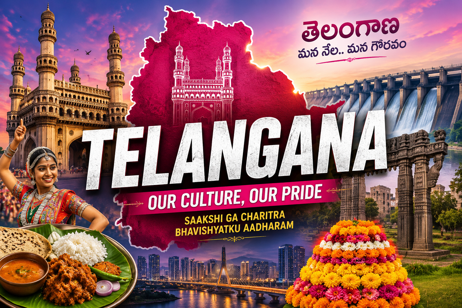
Telangana is one of the fastest-growing states in the country. It is a prominent state in the Southern India which is known for its rich historical background, thriving information technology sector and strong agricultural base. This state was carved out of Andhra Pradesh on the 2nd of June, 2014 after a long-standing statehood movement.
The state is renowned for its ancient dynasties, magnificent forts, world-famous monuments such as Charminar and Golconda Fort. Its capital city Hyderabad, is often referred to as India's "Cyber City" because of its rapid growth in the technological sector. Telangana has emerged as a major centre for information technology, pharmaceuticals, biotechnology, education and innovation.
State Nickname of Telangana
Date of Formation of Telangana
Telangana became the 29th State of India on 2 June 2014.
Historical Background of Telangana
Telangana possesses a rich historical legacy tracing its roots from ancient dynasties like the Satavahanas and Kakatiyas through the medieval Qutb Shahi and Asaf Jahi (Nizam) periods that contributed significantly to its culture, architecture and economy.
Geographical Location of Telangana
Latitude
Longitude
Boundaries
Strategic Location
Climate at a Glance
State Day of Telangana
Telangana celebrates its State Formation Day on 2 June every year.
Capital of Telangana
PIN Code Prefix of Telangana
Area of Telangana
Area-wise Rank of Telangana
Population of Telangana (Census 2011)
Population Rank of Telangana
Population Density
Sex Ratio
Literacy Rate (Census 2011)
Scheduled Caste and Scheduled Tribe Population
Scheduled Caste Population: 17.43%
Scheduled Tribe Population: 10.45%
Others: 72.12%
Tribes of Telangana and Their Habitat
Universities of Telangana
|
No. |
University Name |
Type |
Location (District) |
Established Year |
|
1 |
Osmania University |
State |
Hyderabad |
1918 |
|
2 |
Kakatiya University |
State |
Warangal |
1976 |
|
3 |
University of Hyderabad |
Central |
Hyderabad |
1974 |
|
4 |
Maulana Azad National Urdu University |
Central |
Hyderabad |
1998 |
|
5 |
English and Foreign Languages University |
Central |
Hyderabad |
1958 |
|
6 |
Jawaharlal Nehru Technological University |
State |
Hyderabad |
1972 |
|
7 |
Prof. Jayashankar Telangana State Agricultural University |
State |
Hyderabad |
2014 |
|
8 |
Palamuru University |
State |
Mahabubnagar |
2008 |
|
9 |
Mahatma Gandhi University |
State |
Nalgonda |
2007 |
|
10 |
Telangana University |
State |
Nizamabad |
2006 |
|
11 |
Satavahana University |
State |
Karimnagar |
2008 |
|
12 |
Dr. B.R. Ambedkar Open University |
State |
Hyderabad |
1982 |
|
13 |
Potti Sreeramulu Telugu University |
State |
Hyderabad |
1985 |
|
14 |
Rajiv Gandhi University of Knowledge Technologies |
State |
Nirmal |
2008 |
|
15 |
Kaloji Narayana Rao University of Health Sciences |
State |
Warangal |
2014 |
|
16 |
Sri Konda Laxman Telangana State Horticultural University |
State |
Mulugu |
2014 |
|
17 |
PV Narsimha Rao Telangana Veterinary University |
State |
Hyderabad |
2014 |
|
18 |
NALSAR University of Law |
State |
Medchal-Malkajgiri |
1998 |
|
19 |
National Institute of Technology |
Central |
Warangal |
1959 |
|
20 |
Indian Institute of Technology |
Central |
Sangareddy |
2008 |
State Symbols of Telangana
Religion in Telangana
Official Language of Telangana
Other Languages Spoken
Legislature of Telangana
Telangana has a bicameral legislature.
Legislative Assembly
Legislative Council
Judicature of Telangana
Dance Forms of Telangana
State Song of Telangana
Folklore of Telangana
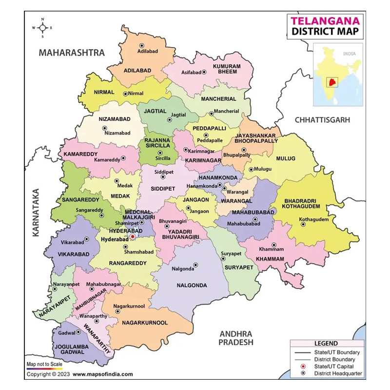
Number of Districts of Telangana with Headquarters
Number of districts: 33
|
No. |
District Name |
Headquarters |
Population |
Population Density (per km²) |
|
1 |
Adilabad |
Adilabad |
7,08,972 |
171 |
|
2 |
Bhadradri Kothagudem |
Kothagudem |
10,69,261 |
143 |
|
3 |
Hanumakonda |
Hanamkonda |
10,80,858 |
826 |
|
4 |
Hyderabad |
Hyderabad |
39,43,323 |
18,172 |
|
5 |
Jagtial |
Jagtial |
9,85,417 |
407 |
|
6 |
Jangaon |
Jangaon |
5,66,376 |
259 |
|
7 |
Jayashankar Bhupalpally |
Bhupalpally |
7,11,434 |
115 |
|
8 |
Jogulamba Gadwal |
Gadwal |
6,09,990 |
208 |
|
9 |
Kamareddy |
Kamareddy |
9,72,625 |
266 |
|
10 |
Karimnagar |
Karimnagar |
10,05,711 |
473 |
|
11 |
Khammam |
Khammam |
14,01,639 |
321 |
|
12 |
Komaram Bheem Asifabad |
Asifabad |
5,15,812 |
106 |
|
13 |
Mahabubabad |
Mahabubabad |
7,74,549 |
269 |
|
14 |
Mahabubnagar |
Mahabubnagar |
9,19,903 |
281 |
|
15 |
Mancherial |
Mancherial |
8,07,037 |
201 |
|
16 |
Medak |
Medak |
7,67,428 |
275 |
|
17 |
Medchal-Malkajgiri |
Shamirpet |
24,40,073 |
2,251 |
|
18 |
Mulugu |
Mulugu |
2,57,744 |
66 |
|
19 |
Nagarkurnool |
Nagarkurnool |
8,93,308 |
142 |
|
20 |
Nalgonda |
Nalgonda |
16,18,416 |
227 |
|
21 |
Narayanpet |
Narayanpet |
5,66,874 |
243 |
|
22 |
Nirmal |
Nirmal |
7,09,418 |
185 |
|
23 |
Nizamabad |
Nizamabad |
15,71,022 |
366 |
|
24 |
Peddapalli |
Peddapalli |
7,95,332 |
356 |
|
25 |
Rajanna Sircilla |
Sircilla |
5,52,037 |
273 |
|
26 |
Rangareddy |
Shamshabad |
24,46,974 |
486 |
|
27 |
Sangareddy |
Sangareddy |
15,27,628 |
347 |
|
28 |
Siddipet |
Siddipet |
10,12,065 |
278 |
|
29 |
Suryapet |
Suryapet |
10,99,560 |
326 |
|
30 |
Vikarabad |
Vikarabad |
9,27,140 |
274 |
|
31 |
Wanaparthy |
Wanaparthy |
5,77,758 |
268 |
|
32 |
Warangal |
Warangal |
7,18,537 |
330 |
|
33 |
Yadadri Bhuvanagiri |
Bhuvanagiri |
7,39,448 |
307 |
Note: Telangana was reorganized from 10 districts into 31 districts in 2016. Mulugu and Narayanpet were added in 2019, bringing the total to 33 districts.
Map of Telangana (District Map)
Number of Sub-Divisions in Telangana
Total Revenue Divisions (Sub-divisions): 74
|
No. |
District |
District Headquarters |
Key Civil Sub-Divisions within the District |
|
1 |
Adilabad |
Adilabad |
Adilabad, Utnoor |
|
2 |
Bhadradri Kothagudem |
Kothagudem |
Kothagudem, Bhadrachalam |
|
3 |
Hanumakonda |
Hanamkonda |
Hanumakonda, Parkal |
|
4 |
Hyderabad |
Hyderabad |
Hyderabad, Secunderabad |
|
5 |
Jagtial |
Jagtial |
Jagtial, Korutla, Metpally |
|
6 |
Jangaon |
Jangaon |
Jangaon, Station Ghanpur |
|
7 |
Jayashankar Bhupalpally |
Bhupalpally |
Bhupalpally |
|
8 |
Jogulamba Gadwal |
Gadwal |
Gadwal |
|
9 |
Kamareddy |
Kamareddy |
Kamareddy, Banswada, Yellareddy |
|
10 |
Karimnagar |
Karimnagar |
Karimnagar, Huzurabad |
|
11 |
Khammam |
Khammam |
Khammam, Kallur |
|
12 |
Komaram Bheem Asifabad |
Asifabad |
Asifabad, Kagaznagar |
|
13 |
Mahabubabad |
Mahabubabad |
Mahabubabad, Thorrur |
|
14 |
Mahabubnagar |
Mahabubnagar |
Mahabubnagar, Badepally |
|
15 |
Mancherial |
Mancherial |
Mancherial, Bellampally |
|
16 |
Medak |
Medak |
Medak, Narsapur, Toopran |
|
17 |
Medchal-Malkajgiri |
Shamirpet |
Keesara, Malkajgiri |
|
18 |
Mulugu |
Mulugu |
Mulugu |
|
19 |
Nagarkurnool |
Nagarkurnool |
Nagarkurnool, Achampet, Kalwakurthy, Kollapur |
|
20 |
Nalgonda |
Nalgonda |
Nalgonda, Miryalaguda, Devarakonda, Chandur |
|
21 |
Narayanpet |
Narayanpet |
Narayanpet |
|
22 |
Nirmal |
Nirmal |
Nirmal, Bhainsa |
|
23 |
Nizamabad |
Nizamabad |
Nizamabad, Bodhan, Armoor |
|
24 |
Peddapalli |
Peddapalli |
Peddapally, Manthani |
|
25 |
Rajanna Sircilla |
Sircilla |
Sircilla, Vemulawada |
|
26 |
Rangareddy |
Shamshabad |
Chevella, Ibrahimpatnam, Rajendranagar, Shadnagar, Kandukur |
|
27 |
Sangareddy |
Sangareddy |
Sangareddy, Narayankhed, Zaheerabad andole |
|
28 |
Siddipet |
Siddipet |
Siddipet, Gajwel, Husnabad |
|
29 |
Suryapet |
Suryapet |
Suryapet, Kodad, Huzurnagar |
|
30 |
Vikarabad |
Vikarabad |
Vikarabad, Tandur |
|
31 |
Wanaparthy |
Wanaparthy |
Wanaparthy |
|
32 |
Warangal |
Warangal |
Warangal, Narsampet |
|
33 |
Yadadri Bhuvanagiri |
Bhuvanagiri |
Bhongir, Choutuppal |
Number of Villages in Telangana
(Note: The number of Gram Panchayats is higher because large villages often get split into multiple administrative councils or smaller hamlets are joined together to form a unique local governance unit).
Number of Mandals (Administrative Blocks)
Lok Sabha Seats of Telangana
Parliamentary Constituencies
Rajya Sabha Seats of Telangana
Vidhan Sabha Seats of Telangana
Main Towns of Telangana
|
No. |
City/Town |
District |
Population (Census 2011) |
|
1 |
Hyderabad |
Hyderabad |
39,43,323 |
|
2 |
Warangal |
Hanumakonda / Warangal |
8,19,406 |
|
3 |
Nizamabad |
Nizamabad |
3,55,081 |
|
4 |
Karimnagar |
Karimnagar |
3,28,870 |
|
5 |
Khammam |
Khammam |
2,86,244 |
|
6 |
Mahabubnagar |
Mahabubnagar |
2,44,856 |
|
7 |
Ramagundam |
Peddapalli |
2,29,644 |
|
8 |
Mancherial |
Mancherial |
1,73,219 |
|
9 |
Nalgonda |
Nalgonda |
1,65,328 |
|
10 |
Kothagudem |
Bhadradri Kothagudem |
1,60,018 |
|
11 |
Adilabad |
Adilabad |
1,55,747 |
|
12 |
Suryapet |
Suryapet |
1,29,461 |
|
13 |
Siddipet |
Siddipet |
1,16,583 |
|
14 |
Miryalaguda |
Nalgonda |
1,08,781 |
|
15 |
Jagtial |
Jagtial |
1,05,735 |
|
16 |
Kamareddy |
Kamareddy |
1,04,393 |
|
17 |
Nirmal |
Nirmal |
88,433 |
|
18 |
Bodhan |
Nizamabad |
77,573 |
|
19 |
Palwancha |
Bhadradri Kothagudem |
76,268 |
|
20 |
Sirpur-Kagaznagar |
Komaram Bheem Asifabad |
57,583 |
|
21 |
Sircilla |
Rajanna Sircilla |
53,185 |
|
22 |
Jangaon |
Jangaon |
52,394 |
|
23 |
Korutla |
Jagtial |
45,450 |
|
24 |
Bhupalpally |
Jayashankar Bhupalpally |
42,387 |
|
25 |
Tandur |
Vikarabad |
40,940 |
Main Crops of Telangana
Main Cash Crops of Telangana
Telangana is one of India's leading producers of cotton and turmeric.
Minerals Found in Telangana
The Singareni Coalfields are among India's most important coal-producing regions.
Rivers Flowing Through Telangana
|
No. |
River Name |
Total Length (Approx.) |
Length in Telangana (Approx.) |
Origin Point |
Confluence / Endpoint |
Key Significance & Features |
|
1 |
Godavari |
1,465 km |
560 km |
Trimbakeshwar, Nashik, Maharashtra |
Bay of Bengal (Antarvedi) |
Largest river in South India; enters state at Kandakurthy; fuels Kaleshwaram Lift Irrigation. |
|
2 |
Krishna |
1,400 km |
430 km |
Mahabaleshwar, Western Ghats, Maharashtra |
Bay of Bengal (Hamsaladeevi) |
Forms natural boundary between TS and AP; feeds massive Nagarjuna Sagar and Srisailam dams. |
|
3 |
Manjira |
724 km |
450 km |
Balaghat Hills, Beed, Maharashtra |
Godavari River (Kandakurthy) |
Longest right-bank tributary of Godavari; vital for Nizam Sagar and Hyderabad's drinking water needs. |
|
4 |
Pranahita |
721 km |
115 km |
Confluence of Wardha & Wainganga (Kaleshwaram) |
Godavari River (Kaleshwaram) |
Formed by the collective flows of Wardha, Penganga and Wainganga; forms border with Maharashtra. |
|
5 |
Bhima |
861 km |
175 km |
Bhimashankar, Western Ghats, Maharashtra |
Krishna River (near Raichur border) |
Major interstate left-bank tributary of Krishna; passes through the Narayanpet border segment. |
|
6 |
Tungabhadra |
531 km |
70 km |
Koodli, Western Ghats, Karnataka |
Krishna River (Sangameswaram) |
Formed by Tunga and Bhadra rivers; borders Jogulamba Gadwal district before connecting with Krishna. |
|
7 |
Musi |
256 km |
256 km |
Ananthagiri Hills, Vikarabad, Telangana |
Krishna River (Wazirabad, Suryapet) |
Flows directly through Hyderabad; highly urbanized basin experiencing major clean-up drives. |
|
8 |
Manair |
130 km |
130 km |
Siricilla Hills, Rajanna Sircilla, Telangana |
Godavari River (Mahadevpur) |
Feeds Upper, Middle and Lower Manair Dams; serves as an essential irrigation artery for Karimnagar. |
|
9 |
Paleru |
150 km |
150 km |
Dakshina Chinnapuram, Jangaon, Telangana |
Krishna River (Jaggayyapeta border) |
Left-bank tributary of Krishna; powers irrigation canals extensively across Suryapet and Khammam. |
|
10 |
Munneru |
195 km |
195 km |
Pakhal Lake, Warangal, Telangana |
Krishna River (Nandigama border) |
Flows rapidly through Mahabubabad and Khammam districts; acts as a vital regional agricultural source. |
|
11 |
Dindi |
153 km |
153 km |
Shahabad Hills, Rangareddy, Telangana |
Krishna River (Nallamala hills) |
Drains the semi-arid, fluoride-affected areas of Nalgonda; regulated by the Dindi Reservoir. |
|
12 |
Kinnerasani |
96 km |
96 km |
Medaram Forest, Mulugu, Telangana |
Godavari River (Bhadrachalam) |
Flows through rich forest corridors; supports Kinnerasani Dam and its surrounding wildlife sanctuary. |
|
13 |
Kadam |
110 km |
110 km |
Bazarhatnoor, Adilabad, Telangana |
Godavari River (Peddapalli border) |
Passes through the Nirmal district; feeds the Kadam Project (Kadam Narayanreddy Project). |
|
14 |
Indravati |
535 km |
35 km (Border) |
Thuamul Rampur, Kalahandi, Odisha |
Godavari River (Somnoor, TS border) |
Acts as a geographical interstate border triplet separating Telangana, Maharashtra and Chhattisgarh. |
|
15 |
Wyra |
90 km |
90 km |
Sharajpet, Khammam, Telangana |
Munneru River (Confluence point) |
A sub-tributary in the Krishna basin; feeds the historic Wyra Reservoir constructed in 1930. |
|
16 |
Pedda Vagu |
75 km |
75 km |
Asifabad Hills, Telangana |
Godavari River (Mancherial) |
A localized northern tributary serving the coal-mining and agricultural belts of Asifabad. |
|
17 |
Dhundhubhi |
108 km |
108 km |
Nayanonipally Hills, Mahabubnagar, Telangana |
Krishna River (Siddeshwaram) |
Also called the Dindi in certain stretches, it cuts deeply through sections of the Nagarkurnool plains. |
|
18 |
Halia |
82 km |
82 km |
Ananthagiri forest stretch, Nalgonda, Telangana |
Krishna River (Maddimadugu) |
Left-bank tributary of Krishna flowing past crucial upland layouts of Nalgonda district. |
Mountains and Hills of Telangana
|
No. |
Peak / Hill Name |
Approximate Elevation |
Location (District) |
Cultural & Historical Significance |
|
1 |
Ananthagiri Hills |
700 m (2,296 ft) |
Vikarabad |
Origin point of the Musi River; features the ancient, historic Anantha Padmanabha Swamy Temple built by Nizam-era rulers. |
|
2 |
Nallamala Hills (Amrabad Stretch) |
920 m (3,018 ft) |
Nagarkurnool |
Home to the Amrabad Tiger Reserve and the indigenous Chenchu tribe; features deep spiritual links to the Srisailam holy forest axis. |
|
3 |
Sirasilla Hills (Rakhi Hills) |
600 m (1,968 ft) |
Rajanna Sircilla |
Famous for unique rock formations and rich biodiversity; historically used as strategic watch-posts during regional mediaeval rule. |
|
4 |
Bhongir Hill (Bhuvanagiri) |
610 m (2,001 ft) |
Yadadri Bhuvanagiri |
A massive, monolithic rock structure featuring the spectacular 10th-century Bhongir Fort built by Western Chalukya ruler Tribhuvanamalla Vikramaditya VI. |
|
5 |
Kanakagiri Hills |
550 m (1,804 ft) |
Mahabubnagar |
A scenic hill range holding cultural prominence due to the historic Kanakachalapathi Temple and ancient rock-cut steps. |
|
6 |
Pandavula Gutta |
450 m (1,476 ft) |
Jayashankar Bhupalpally |
A globally recognized heritage site famous for prehistoric rock paintings dating back to the Mesolithic era, depicting ancient wildlife and tribal symbols. |
|
7 |
Nirmal Hills |
500 m (1,640 ft) |
Nirmal |
Strategic defensive hill tracks housing the French-designed 18th-century Shyamgarh and Nirmal Forts, constructed under the Nawabs of Nirmal. |
|
8 |
Khammam Fort Hill |
340 m (1,115 ft) |
Khammam |
Stands as a central urban landmark; holds the historic Khammam Fort built in 950 AD by the Kakatiya rulers, blending Hindu and Islamic architecture. |
|
9 |
Devarakonda Hill |
420 m (1,378 ft) |
Nalgonda |
Features a formidable hilltop fortress built by the Recherla Nayaka kings in the 14th century, standing as a symbol of structural military engineering. |
|
10 |
Ghanpur Hill Range |
400 m (1,312 ft) |
Jayashankar Bhupalpally |
Surrounds the spectacular 13th-century Ghanpur Kota Temples (Kota Gullu) built by the Kakatiyas, exhibiting rich architectural stone heritage. |
|
11 |
Ramagiri Khilla Hill |
300 m (984 ft) |
Peddapalli |
A hilltop historically filled with diverse medicinal plants; houses an ancient fort constructed by the Kakatiyas, later held by the Qutb Shahis. |
|
12 |
Rachakonda Hills |
520 m (1,706 ft) |
Yadadri Bhuvanagiri / Rangareddy |
The historic 14th-century capital site of the Recherla Nayaka kings; famous for strategic rock-cut gateways, ancient stone reservoirs and trekking. |
Industries of Telangana
|
No. |
Sector Type |
Major Economic Activity |
|
1 |
Information Technology (IT) & ITES |
Software development, global capability centres (GCCs), business process outsourcing, AI research and tech hardware design. |
|
2 |
Pharmaceuticals & Lifesciences |
Bulk drug manufacturing, vaccine production, biotechnology, clinical research and genomic therapeutics (centered in Genome Valley). |
|
3 |
Aerospace & Defence |
Manufacturing of helicopter cabins, aircraft fuselages, missile systems, radar components and unmanned aerial vehicles (UAVs). |
|
4 |
Textiles & Apparel |
Cotton ginning, automated spinning mills, synthetic fiber production, powerlooms and mega apparel manufacturing (centered in Kakatiya Mega Textile Park). |
|
5 |
Automobile & Auto Components |
Manufacturing of electronic vehicle (EV) batteries, commercial vehicle parts, tractors and precision engineering castings. |
|
6 |
Food Processing & Agro-Based |
Rice milling, spice processing, seed production, edible oil refining, dairy processing and cold-chain logistics networks. |
|
7 |
Electronics System Design & Manufacturing (ESDM) |
Mobile phone assembly, consumer electronics manufacturing, printed circuit board (PCB) fabrication and semiconductor packaging. |
|
8 |
Minerals & Mining |
Coal extraction (Singareni Collieries), granite quarrying, limestone mining and cement manufacturing. |
|
9 |
Renewable Energy |
Solar power generation, wind energy farming, solar cell manufacturing and green hydrogen infrastructure development. |
|
10 |
Gems & Jewellery |
Diamond cutting and polishing, traditional gold jewelry fabrication, pearl processing and silver filigree craft. |
Economy of Telangana
|
No. |
Sector Type |
Percentage Share of GSDP |
Key Drivers & Sub-Sectors |
|
1 |
Services Sector |
66.30% |
Information Technology (IT/ITeS), global capability centres (GCCs), banking, financial services, real estate and trade/hotels. |
|
2 |
Agriculture and Allied Activities |
17.30% |
Crop cultivation (paddy, cotton, maize), horticulture, livestock rearing, dairy farming, poultry and inland fisheries. |
|
3 |
Manufacturing |
8% to 10% approx. |
Pharmaceuticals, biotechnology (Genome Valley), aerospace and defense, textiles (KMTP), electronics and automobile components. |
|
4 |
Mining and Quarrying |
1.5% to 2% approx. |
Coal extraction (Singareni Collieries), granite mining, limestone quarrying and mineral-based cement manufacturing. |
Airports of Telangana
|
No. |
Airport Name |
Location / City |
IATA Code |
Type |
Status |
|
1 |
Rajiv Gandhi International Airport |
Shamshabad, Hyderabad |
HYD |
International |
Operational (Commercial) |
|
2 |
Begumpet Airport |
Begumpet, Hyderabad |
BPM |
Domestic |
Non-operational (VIP / Defence / Aviation Academy) |
|
3 |
Kakatiya International Airport |
Mamnoor, Warangal |
WGC |
Domestic |
Under Development (Approved / Land Acquired) |
|
4 |
Adilabad Airport |
Adilabad |
NIL |
Domestic |
Under Development (Approved / Joint Civil-Defence) |
|
5 |
Ramagundam Airport |
Ramagundam |
RMD |
Domestic |
Non-operational (VIP / Emergency movements only) |
|
6 |
Dundigal Air Force Academy |
Dundigal, Hyderabad |
NIL |
Military |
Operational (Military Training Base) |
|
7 |
Hakimpet Air Force Station |
Hakimpet, Secunderabad |
NIL |
Military |
Operational (Military Training Base) |
|
8 |
Nadirgul Airfield |
Nadirgul, Hyderabad |
NIL |
Domestic |
Operational (Pilot Training School Base) |
Major Railway Stations of Telangana
|
No. |
Station Name |
Station Code |
District Location |
Railway Zone / Division |
Station Type / Status |
|
1 |
Secunderabad Junction |
SC |
Hyderabad |
SCR / Secunderabad |
Operational (Major Non-Suburban Terminal / NSG-1 Category) |
|
2 |
Hyderabad Deccan (Nampally) |
HYB |
Hyderabad |
SCR / Secunderabad |
Operational (Major Terminal / Headquarter Station) |
|
3 |
Kacheguda |
KCG |
Hyderabad |
SCR / Hyderabad |
Operational (Major Terminal / Historic Heritage Hub) |
|
4 |
Kazipet Junction |
KZJ |
Hanumakonda |
SCR / Secunderabad |
Operational (Crucial North-South Junction & Locomotive Shed) |
|
5 |
Warangal |
WL |
Warangal |
SCR / Secunderabad |
Operational (Major Commercial Hub / Class-A Station) |
|
6 |
Khammam |
KMT |
Khammam |
SCR / Secunderabad |
Operational (High-Traffic Commercial Hub / Class-A Station) |
|
7 |
Nizamabad Junction |
NZB |
Nizamabad |
SCR / Hyderabad |
Operational (Major Northern Junction / Multi-Line Connectivity) |
|
8 |
Karimnagar |
KRMR |
Karimnagar |
SCR / Secunderabad |
Operational (Important District Terminal) |
|
9 |
Ramagundam |
RDM |
Peddapalli |
SCR / Secunderabad |
Operational (High-Traffic Industrial Hub / Coal Belt Link) |
|
10 |
Peddapalli Junction |
PDPL |
Peddapalli |
SCR / Secunderabad |
Operational (Junction connecting Nizamabad & Karimnagar lines) |
|
11 |
Mahabubnagar |
MBNR |
Mahabubnagar |
SCR / Hyderabad |
Operational (Major Southern Hub / District Headquarter) |
|
12 |
Nalgonda |
NLDA |
Nalgonda |
SCR / Guntur |
Operational (Key Transit Hub on the Guntur-Secunderabad line) |
|
13 |
Bhongir |
BG |
Yadadri Bhuvanagiri |
SCR / Secunderabad |
Operational (Important Suburban & Commuter Stop) |
|
14 |
Lingampalli |
LPI |
Rangareddy |
SCR / Secunderabad |
Operational (Major Terminating Station for Western Suburbs & MMTS) |
|
15 |
Mancherial |
MCI |
Mancherial |
SCR / Secunderabad |
Operational (Key Passenger Stop for Northern Industrial Belt) |
|
16 |
Vikarabad Junction |
VKB |
Vikarabad |
SCR / Secunderabad |
Operational (Crucial Junction connecting Karnataka/Maharashtra lines) |
|
17 |
Tandur |
TDU |
Vikarabad |
SCR / Secunderabad |
Operational (Major Industrial Mineral Transit Station) |
|
18 |
Jagtial (Lingampet Jagtial) |
LPJL |
Jagtial |
SCR / Secunderabad |
Operational (Key Stop on the Karimnagar-Nizamabad line) |
|
19 |
Kamareddy |
KMC |
Kamareddy |
SCR / Hyderabad |
Operational (Important Passenger Stop on the Secunderabad-Manmad route) |
|
20 |
Cherlapally |
CHZ |
Medchal-Malkajgiri |
SCR / Secunderabad |
Operational (Newly Developed Mega Terminal for Eastern Hyderabad) |
Major Roads and Highways of Telangana
|
No. |
Highway |
Route Segment within Telangana |
|
1 |
NH 44 (Old NH 7) |
Adilabad -> Nirmal -> Kamareddy -> Nizamabad -> Hyderabad -> Mahabubnagar -> Alampur (Borders AP) |
|
2 |
NH 65 (Old NH 9) |
Zahirabad (Borders KA) -> Sangareddy -> Hyderabad -> Suryapet -> Kodad (Borders AP) |
|
3 |
NH 163 (Old NH 202) |
Hyderabad -> Yadadri Bhuvanagiri -> Jangaon -> Hanumakonda -> Warangal -> Mulugu -> Eturunagaram (Borders CG) |
|
4 |
NH 30 (Old NH 221) |
Kunavaram border -> Bhadrachalam -> Palwancha -> Kothagudem -> Penuballi -> Wyra -> Khammam |
|
5 |
NH 563 |
Jagtial -> Karimnagar -> Choppadandi -> Hanumakonda -> Warangal -> Khammam |
|
6 |
NH 63 (Old NH 16) |
Nizamabad -> Armoor -> Metpally -> Jagtial -> Mancherial -> Chennur (Borders MH) |
|
7 |
NH 765 |
Hyderabad -> Maisigandi -> Kalwakurthy -> Midgil -> Nagarkurnool -> Achampet -> Srisailam Forest edge |
|
8 |
NH 167 |
Haggari (Borders KA) -> Narayanpet -> Mahabubnagar -> Jadcherla -> Kalwakurthy -> Devarakonda -> Miryalaguda |
|
9 |
NH 365 |
Jnakampet -> Bodhan -> Nizamabad -> Siddipet -> Jangaon -> Mahabubabad -> Khammam |
|
10 |
ORR (State Expressway) |
158 km Nehru Outer Ring Road encircling the entire Hyderabad metropolitan urban layout (8-lane expressway) |
Hydroelectric Power Projects of Telangana
|
No. |
Project Name |
Installed Capacity |
River/Stream |
Location |
Status |
|
1 |
Srisailam Left Bank H.E.P. |
900 MW (6 x 150 MW) |
Krishna River |
Nagarkurnool District |
Operational (India's largest underground powerhouse) |
|
2 |
Nagarjuna Sagar Main House |
815.6 MW (1 x 110 + 7 x 100.8 MW) |
Krishna River |
Nalgonda District |
Operational (Major multi-purpose peaking station) |
|
3 |
Lower Jurala H.E.P. |
240 MW (6 x 40 MW) |
Krishna River |
Jogulamba Gadwal District |
Operational |
|
4 |
Priyadarshini Jurala H.E.P. |
234 MW (6 x 39 MW) |
Krishna River |
Jogulamba Gadwal District |
Operational (Joint project with Karnataka) |
|
5 |
Puttamgandi H.E.P. (AMRP) |
72 MW (4 x 18 MW) |
Krishna River (Canal) |
Nalgonda District |
Operational (Part of Alimineti Madhava Reddy Project) |
|
6 |
Nagarjuna Sagar Left Canal H.E.P. |
60 MW (2 x 30 MW) |
Krishna River (Canal) |
Nalgonda District |
Operational |
|
7 |
Sri Rama Sagar (Pochampad) H.E.P. |
36 MW (4 x 9 MW) |
Godavari River |
Nizamabad District |
Operational |
|
8 |
Singur H.E.P. |
15 MW (2 x 7.5 MW) |
Manjira River |
Sangareddy District |
Operational |
|
9 |
Nizamsagar H.E.P. |
10 MW (2 x 5 MW) |
Manjira River |
Kamareddy District |
Operational |
|
10 |
Nagarjuna Sagar Tail Pond H.E.P. |
50 MW (2 x 25 MW) |
Krishna River |
Nalgonda Border |
Operational |
|
11 |
Sitamma Sagar H.E.P. |
320 MW (8 x 40 MW) |
Godavari River |
Bhadradri Kothagudem |
Under Development (Approved / Pre-construction) |
|
12 |
Sammakka Sagar (Dummugudem) H.E.P. |
240 MW (8 x 30 MW) |
Godavari River |
Mulugu District |
Under Development (Approved / Pre-construction) |
|
13 |
Peddapalli Mini Hydel Plant |
1.32 MW |
Kakatiya Canal |
Peddapalli District |
Operational (Small Hydro Unit) |
Thermal Power Projects of Telangana
|
No. |
Project Name |
Installed Capacity |
Location |
Status |
|
1 |
NTPC Ramagundam STPS |
2,600 MW |
Peddapalli District |
Operational (Central Sector / One of India's largest) |
|
2 |
Kothagudem Thermal Power Station (KTPS) |
1,800 MW |
Bhadradri Kothagudem |
Operational (State Sector / Multi-stage expansion hub) |
|
3 |
Telangana Super Thermal Power Project |
1,600 MW |
Peddapalli District |
Operational (NTPC Phase-1 completed; Phase-2 planned for 4,000 MW total) |
|
4 |
Singareni Thermal Power Plant (STPP) |
1,200 MW |
Mancherial District |
Operational (SCCL-owned; 800 MW Phase-2 unit expansion under construction) |
|
5 |
Kakatiya Thermal Power Plant (KTPP) |
1,100 MW |
Jayashankar Bhupalpally |
Operational (State Sector / Uses Tadicherla coal mines) |
|
6 |
Bhadradri Thermal Power Station |
1,080 MW |
Bhadradri Kothagudem |
Operational (State Sector / Uses subcritical technology) |
|
7 |
Yadadri Thermal Power Station (YTPS) |
3,200 MW |
Nalgonda District |
Operational (4 out of 5 units active; final unit target to hit 4,000 MW capacity) |
|
8 |
Ramagundam B Thermal Power Station |
62.5 MW |
Peddapalli District |
Operational (Vintage legacy unit / Secondary stabilizer) |
Museums of Telangana
Space Research Centre of Telangana
Wildlife Sanctuaries and National Parks of Telangana
|
No. |
National Parks / Wildlife Sanctuaries / Tiger Reserves |
District |
Key Wildlife Species |
Notable Feature |
|
1 |
Amrabad Tiger Reserve |
Nagarkurnool & Nalgonda |
Tiger, Leopard, Sloth Bear |
One of India's largest tiger reserves |
|
2 |
Kawal Tiger Reserve |
Adilabad, Nirmal, Mancherial |
Tiger, Leopard, Gaur |
Important tiger habitat in Telangana |
|
3 |
Kinnerasani Wildlife Sanctuary |
Bhadradri Kothagudem |
Leopard, Wild Boar, Deer |
Known for Kinnerasani Reservoir |
|
4 |
Pocharam Wildlife Sanctuary |
Medak & Nizamabad |
Blackbuck, Chital |
Former hunting ground of Nizams |
|
5 |
Manjira Wildlife Sanctuary |
Sangareddy |
Marsh Crocodile, Water Birds |
Famous for crocodile conservation |
|
6 |
Eturnagaram Wildlife Sanctuary |
Mulugu |
Gaur, Sambar, Sloth Bear |
One of the oldest sanctuaries in Telangana |
|
7 |
Pakhal Wildlife Sanctuary |
Warangal |
Leopard, Deer, Wild Boar |
Located around Pakhal Lake |
|
8 |
Mrugavani National Park |
Hyderabad |
Deer, Reptiles, Birds |
Urban national park |
|
9 |
Mahavir Harina Vanasthali National Park |
Hyderabad |
Blackbuck |
Important urban biodiversity park |
|
10 |
Kasu Brahmananda Reddy National Park |
Hyderabad |
Peacocks, Small Mammals |
Located in the heart of Hyderabad |
UNESCO World Heritage Site
Festivals of Telangana
Historical Places of Telangana
Tourist Places of Telangana
Natural Attractions
Cultural Attractions
Wildlife Attractions
First Governor of Telangana
First Chief Minister of Telangana
Great Personalities of Telangana
Political Leaders
Cultural Personalities
Sports Personalities
Conclusion
Telangana is one of India's most dynamic and rapidly developing states in India. From the architectural marvels like Charminar, Golconda Fort and Ramappa Temple to the colourful celebrations of Bathukamma and Bonalu, its rich cultural history and technological sector advancement in the recent years make the state a unique blend of tradition and modernity. Its extensive irrigation projects, growing industrial base and strategic location on the Deccan Plateau contributes significantly to India's economic development.