
Introduction
Jharkhand, also known as “The Land of Forests,” is a beautiful state in eastern India that was carved out of Bihar in 2000. This state is special because of the Chota Nagpur Plateau, which has many mesmerizing landscapes, including rolling hills, dense deciduous forests, and waterfalls. This state is a great place for nature lovers to experience greenery at its peak, with over 29% of the area covered by lush forests dominated by the sacred Sal tree.
Apart from the breathtaking landscapes, Jharkhand is also a powerhouse of most of the minerals found in India. It holds nearly 40% of India’s total mineral wealth, which has led to the growth of large-scale industries in Jamshedpur and Dhanbad. It must be noted that Jharkhand owes much of its identity to its indigenous culture. About 25% of the total population comprises tribal groups such as Santhal, Munda, and Oraon, who are deeply connected to nature through their colourful festivals, Sarhul and Karma.
State Nicknames of Jharkhand
Date of Formation of Jharkhand
History of Jharkhand
Early and Colonial Eras
Jharkhand has a history of ancient heritage and tribal existence. It was under the rule of the Nagvanshi Dynasty from the 1st century AD; later, it came under British rule after the 1765 Diwani grant. Due to heavy exploitation of resources, the rise of legendary rebellions in history, that includes the Tilka Manjhi Revolt (1780-85), the Kol Revolt (1831-32) led by Buddhu Bhagat, the Santhal Hul (1855-56) initiated by Sidhu-Kanhu, and the famous Ulgulan (1895-1900) led by Birsa Munda.
The Statehood Movement
The Statehood Movement began in 1915 with the Chotanagpur Unnati Samaj, later continued with the formation of the Jharkhand Party in 1950 by Jaipal Singh Munda, who demanded separation. This struggle extended in 1972 when Jharkhand Mukti Morcha (JMM) was established by Shibu Soren and Binod Bihari Mahato. Finally, after many years of widespread popular unrest, the Bihar Reorganisation Bill was passed, making Jharkhand officially India’s 28th state on November 15, 2000, making that day Birsa Munda’s birth anniversary.
Geographical Location of Jharkhand
Boundaries
Strategic Location
Climate at a Glance
State Day of Jharkhand
Capital of Jharkhand
PIN Code Prefix of Jharkhand
Area of Jharkhand
Area-Wise Rank of Jharkhand
Population of Jharkhand (Census 2011)
Population Rank of Jharkhand
Population Density
Sex Ratio
Literacy Rate
According to the Periodic Labour Force Survey (PLFS) 2023–24, Jharkhand recorded an overall literacy rate of 76.7%. The literacy rate for Jharkhand's population aged 7 and above is:
Scheduled Caste and Scheduled Tribe Population
Scheduled Caste Population
Scheduled Tribe Population
Others
Tribes of Jharkhand and their Habitat
Universities of Jharkhand
|
S.No. |
University |
Location |
|
1 |
Central University of Jharkhand |
Ranchi |
|
2 |
Ranchi University |
Ranchi |
|
3 |
Binod Bihari Mahto Koylanchal University |
Dhanbad |
|
4 |
Vinoba Bhave University |
Hazaribagh |
|
5 |
Sido Kanhu Murmu University |
Dumka |
|
6 |
Kolhan University |
Chaibasa |
|
7 |
Nilamber-Pitamber University |
Palamu |
|
8 |
Dr. Shyama Prasad Mukherjee University |
Ranchi |
|
9 |
Jamshedpur Women's University |
Jamshedpur |
|
10 |
Birsa Agricultural University |
Ranchi |
|
11 |
Jharkhand University of Technology |
Ranchi |
|
12 |
National University of Study and Research in Law |
Ranchi |
|
13 |
Jharkhand Raksha Shakti University |
Ranchi |
|
14 |
Jharkhand State Open University |
Ranchi |
|
15 |
Birla Institute of Technology (BIT Mesra) |
Ranchi |
|
16 |
National Institute of Technology (NIT) |
Jamshedpur |
|
17 |
Indian Institute of Technology (IIT ISM) |
Dhanbad |
|
18 |
Indian Institute of Management (IIM) |
Ranchi |
|
19 |
Indian Institute of Information Technology (IIIT) |
Ranchi |
|
20 |
National Institute of Advanced Manufacturing Technology (NIAMT) |
Ranchi |
|
21 |
All India Institute of Medical Sciences (AIIMS) |
Deoghar |
|
22 |
Amity University |
Ranchi |
|
23 |
Sarala Birla University |
Ranchi |
|
24 |
Usha Martin University |
Ranchi |
|
25 |
Arka Jain University |
Seraikela Kharsawan |
|
26 |
Netaji Subhas University |
Jamshedpur |
|
27 |
AISECT University |
Hazaribagh |
|
28 |
ICFAI University |
Ranchi |
|
29 |
Jharkhand Rai University |
Ranchi |
|
30 |
Radha Govind University |
Ramgarh |
|
31 |
YBN University |
Ranchi |
|
32 |
Capital University |
Koderma |
|
33 |
Sai Nath University |
Ranchi |
State Symbols of Jharkhand
Religion in Jharkhand (Census 2011)
Official Language of Jharkhand
Other Languages Spoken
Legislature of Jharkhand
Legislative Assembly (Vidhan Sabha)
Judicature of Jharkhand
Dance Forms of Jharkhand
State Song of Jharkhand
Folklore of Jharkhand
Number of Districts of Jharkhand with Headquarters
|
S.No. |
District |
Headquarters |
Established in |
Area (sq. km.) |
Population (Census 2011) |
Population Density (per sq. km.) |
|
1 |
Bokaro |
Bokaro |
1991 |
2,883 |
2,061,918 |
716 |
|
2 |
Chatra |
Chatra |
1991 |
3,700 |
1,042,304 |
275 |
|
3 |
Deoghar |
Deoghar |
1983 |
2,479 |
1,491,879 |
602 |
|
4 |
Dhanbad |
Dhanbad |
1956 |
2,040 |
2,682,662 |
1,316 |
|
5 |
Dumka |
Dumka |
1865 |
4,404 |
1,321,096 |
300 |
|
6 |
East Singhbhum |
Jamshedpur |
1990 |
3,562 |
2,291,032 |
648 |
|
7 |
Garhwa |
Garhwa |
1991 |
4,064 |
1,322,387 |
327 |
|
8 |
Giridih |
Giridih |
1972 |
4,887 |
2,445,203 |
497 |
|
9 |
Godda |
Godda |
1983 |
2,110 |
1,311,382 |
622 |
|
10 |
Gumla |
Gumla |
1983 |
5,360 |
1,025,656 |
191 |
|
11 |
Hazaribagh |
Hazaribag |
1834 |
3,555 |
1,734,495 |
488 |
|
12 |
Jamtara |
Jamtara |
2001 |
1,802 |
790,207 |
439 |
|
13 |
Khunti |
Khunti |
2007 |
2,535 |
530,299 |
210 |
|
14 |
Koderma |
Koderma |
1994 |
2,540 |
716,259 |
282 |
|
15 |
Latehar |
Latehar |
2001 |
3,630 |
725,673 |
200 |
|
16 |
Lohardaga |
Lohardaga |
1983 |
1,502 |
461,738 |
307 |
|
17 |
Pakur |
Pakur |
1994 |
1,805 |
899,200 |
498 |
|
18 |
Palamu |
Medininagar (Daltonganj) |
1892 |
4,393 |
1,936,319 |
442 |
|
19 |
Ramgarh |
Ramgarh |
2007 |
1,341 |
949,159 |
708 |
|
20 |
Ranchi |
Ranchi |
1899 |
5,097 |
2,912,022 |
572 |
|
21 |
Sahibganj |
Sahibganj |
1983 |
2,063 |
1,150,038 |
558 |
|
22 |
Seraikela-Kharsawan |
Seraikela |
2001 |
2,657 |
1,063,458 |
401 |
|
23 |
Simdega |
Simdega |
2001 |
3,750 |
599,813 |
160 |
|
24 |
West Singhbhum |
Chaibasa |
1990 |
7,224 |
1,501,619 |
209 |
Important District Facts (Jharkhand)
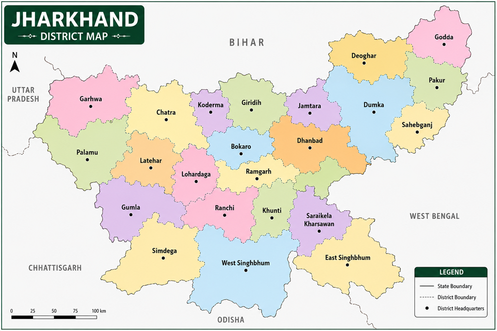
Note: Jharkhand currently has 24 districts, which are classified into 5 administrative divisions - North Chotanagpur, South Chotanagpur, Kolhan, Palamu, and Santhal Pargana. The state was born out of Bihar on 15 November 2000, becoming the 28th state of India. The latest districts are Khunti and Ramgarh, both created in 2007. Ranchi serves as the state capital, whereas Dumka is the sub-capital.
Map of Jharkhand (District Map)
Sub-Divisions of Jharkhand
|
S.No. |
District |
Headquarters |
Key Civil Sub-divisions within the District |
|
1 |
Bokaro |
Bokaro |
Bermo, Chas |
|
2 |
Chatra |
Chatra |
Chatra, Simaria |
|
3 |
Deoghar |
Deoghar |
Deoghar, Madhupur |
|
4 |
Dhanbad |
Dhanbad |
Dhanbad, Baghmara |
|
5 |
Dumka |
Dumka |
Dumka |
|
6 |
East Singhbhum |
Jamshedpur |
Dhalbhum, Ghatsila |
|
7 |
Garhwa |
Garhwa |
Garhwa, Ranka |
|
8 |
Giridih |
Giridih |
Giridih, Dumri, Khori Mahua |
|
9 |
Godda |
Godda |
Godda, Mahagama |
|
10 |
Gumla |
Gumla |
Gumla, Chainpur, Basia |
|
11 |
Hazaribagh |
Hazaribag |
Hazaribag, Barhi |
|
12 |
Jamtara |
Jamtara |
Jamtara |
|
13 |
Khunti |
Khunti |
Khunti |
|
14 |
Koderma |
Koderma |
Koderma |
|
15 |
Latehar |
Latehar |
Latehar |
|
16 |
Lohardaga |
Lohardaga |
Lohardaga |
|
17 |
Pakur |
Pakur |
Pakur |
|
18 |
Palamu |
Medininagar (Daltonganj) |
Medininagar, Hussainabad, Chhatarpur |
|
19 |
Ramgarh |
Ramgarh |
Ramgarh |
|
20 |
Ranchi |
Ranchi |
Ranchi, Bundu |
|
21 |
Sahibganj |
Sahibganj |
Sahibganj, Rajmahal |
|
22 |
Seraikela-Kharsawan |
Seraikela |
Seraikela, Chandil |
|
23 |
Simdega |
Simdega |
Simdega |
|
24 |
West Singhbhum |
Chaibasa |
Chaibasa, Chakradharpur |
Number of Villages in Jharkhand
Number of Blocks
Lok Sabha Seats of Jharkhand
Parliamentary Constituencies
Rajya Sabha Seats of Jharkhand
Vidhan Sabha Seats of Jharkhand
Main Towns of Jharkhand
|
S.No. |
City/Town |
District |
Population (Census 2011) |
|
1 |
Ranchi |
Ranchi |
1,073,427 |
|
2 |
Jamshedpur |
East Singhbhum |
629,659 |
|
3 |
Dhanbad |
Dhanbad |
1,162,472 |
|
4 |
Bokaro Steel City |
Bokaro |
563,417 |
|
5 |
Deoghar |
Deoghar |
203,123 |
|
6 |
Hazaribag |
Hazaribagh |
142,489 |
|
7 |
Giridih |
Giridih |
143,529 |
|
8 |
Ramgarh |
Ramgarh |
121,887 |
|
9 |
Medininagar (Daltonganj) |
Palamu |
78,396 |
|
10 |
Chirkunda |
Dhanbad |
45,548 |
|
11 |
Phusro |
Bokaro |
89,064 |
|
12 |
Chas |
Bokaro |
141,640 |
|
13 |
Dumka |
Dumka |
47,454 |
|
14 |
Sahibganj |
Sahibganj |
88,214 |
|
15 |
Chaibasa |
West Singhbhum |
69,565 |
|
16 |
Lohardaga |
Lohardaga |
57,411 |
|
17 |
Gumla |
Gumla |
45,548 |
|
18 |
Simdega |
Simdega |
42,944 |
|
19 |
Pakur |
Pakur |
45,840 |
|
20 |
Godda |
Godda |
48,480 |
|
21 |
Chatra |
Chatra |
49,985 |
|
22 |
Jamtara |
Jamtara |
29,415 |
|
23 |
Khunti |
Khunti |
33,611 |
|
24 |
Koderma |
Koderma |
24,633 |
Main Crops of Jharkhand
Main Cash Crops of Jharkhand
Minerals Found in Jharkhand
Rivers Flowing Through Jharkhand
|
S.No. |
River Name |
Total Length (Approx.) |
Length in Jharkhand (Approx.) |
Origin Point |
Confluence / Endpoint |
Key Significance & Features |
|
1 |
Damodar |
592 km |
290 km |
Khamarpat Hill, Latehar district |
Hooghly River (West Bengal) |
Known as the "River of Sorrows"; Damodar Valley Corporation (DVC) dams; major industrial river. |
|
2 |
Subarnarekha |
474 km |
290 km |
Nagri village near Ranchi |
Bay of Bengal near Kirtania (Odisha) |
Means "Streak of Gold"; flows through Ranchi and Jamshedpur; supports industries. |
|
3 |
North Koel |
260 km |
200 km |
Ranchi Plateau, Latehar district |
Joins the Son River (Bihar) |
Major tributary of the Son; North Koel Reservoir Project. |
|
4 |
South Koel |
483 km |
260 km |
Nagri village near Ranchi |
Joins Sankh River to form Brahmani River (Odisha) |
Important river of southern Jharkhand; irrigation and hydroelectric potential. |
|
5 |
Sankh |
240 km |
150 km |
Near Lupungpat, Gumla district |
Meets South Koel at Vedvyas (Odisha) |
Forms the Brahmani River; flows through dense forests and tribal areas. |
|
6 |
Barakar |
225 km |
170 km |
Hazaribagh Plateau |
Joins Damodar River at Dishergarh (West Bengal) |
Site of Maithon Dam and Tilaiya Dam; important DVC river. |
|
7 |
Ajay |
288 km |
140 km |
Munger Hills (Jamui district, Bihar) |
Bhagirathi-Hooghly River (West Bengal) |
Forms part of Jharkhand–West Bengal boundary; supports agriculture. |
|
8 |
Mayurakshi |
250 km |
110 km |
Trikut Hills, Deoghar district |
Bhagirathi River (West Bengal) |
Famous for Massanjore Dam; irrigation in Jharkhand and West Bengal. |
|
9 |
Kharkai |
161 km |
90 km |
Simlipal Hills (Odisha) |
Joins Subarnarekha at Jamshedpur |
Important river for Jamshedpur; supports Tata Steel's industrial region. |
|
10 |
Kanchi |
80 km |
80 km |
Ranchi Plateau |
Joins Subarnarekha River |
Scenic river; home to Dassam Falls. |
|
11 |
Karo |
70 km |
70 km |
Ranchi Plateau |
Joins South Koel River |
Important tributary in the Kolhan region; hydroelectric potential. |
|
12 |
Amanat |
120 km |
120 km |
Latehar district |
Joins North Koel River |
Supports irrigation and agriculture in Palamu region. |
|
13 |
Konar |
96 km |
96 km |
Hazaribagh Plateau |
Joins Damodar River |
Site of Konar Dam, one of the DVC projects. |
|
14 |
Brahmani (Jharkhand tributary system) |
799 km (total) |
~35 km |
Formed by Sankh & South Koel at Vedvyas (Odisha) |
Bay of Bengal |
Briefly flows along Jharkhand border before entering Odisha. |
|
15 |
Bansloi |
112 km |
70 km |
Sahibganj district |
Joins Bhagirathi River (West Bengal) |
Important river of the Santhal Pargana region. |
|
16 |
Gumani |
80 km |
80 km |
Rajmahal Hills |
Joins the Ganga River |
Seasonal river flowing through Sahibganj district. |
|
17 |
Punpun |
200 km |
45 km |
Palamu district |
Joins the Ganga near Fatuha (Bihar) |
Important tributary of the Ganga; seasonal in nature. |
|
18 |
Son |
784 km |
65 km |
Amarkantak Plateau (Madhya Pradesh) |
Joins the Ganga near Patna (Bihar) |
Forms part of Jharkhand's northwestern drainage; receives North Koel. |
|
19 |
Ganga |
2,525 km |
83 km |
Gangotri Glacier (Uttarakhand) |
Bay of Bengal |
Flows along the northern boundary of Jharkhand through Sahibganj district. |
Major Falls in Jharkhand
|
S.No. |
Waterfall |
District |
River |
Height (Approx.) |
Key Significance / Features |
|
1 |
Hundru Falls |
Ranchi |
Subarnarekha River |
98 m (322 ft) |
Highest and most famous waterfall in Jharkhand |
|
2 |
Dassam Falls |
Ranchi |
Kanchi River |
44 m (144 ft) |
Popular tourist destination |
|
3 |
Jonha Falls (Gautamdhara) |
Ranchi |
Raru River |
43 m (141 ft) |
Buddhist pilgrimage site |
|
4 |
Hirni Falls |
West Singhbhum |
Ramgarha River |
37 m (121 ft) |
Scenic forest waterfall |
|
5 |
Panchghagh Falls |
Khunti |
Banai River |
15 m (49 ft) |
Five-stream waterfall |
|
6 |
Sita Falls |
Ranchi |
Kanchi River |
30 m (98 ft) |
Peaceful picnic spot |
|
7 |
Rajrappa Falls |
Ramgarh |
Bhairavi River |
9 m (30 ft) |
Confluence with Damodar; Chhinnamasta Temple |
|
8 |
Lodh Falls (Budha Ghagh) |
Latehar |
Burha River |
143 m (469 ft) |
Highest waterfall in Jharkhand |
|
9 |
Sadni Falls |
Gumla |
Sankh River |
60 m (197 ft) |
Picturesque natural waterfall |
|
10 |
Ghaghri Falls (Upper) |
Netarhat, Latehar |
Ghaghri River |
30 m (98 ft) |
Popular Netarhat attraction |
|
11 |
Ghaghri Falls (Lower) |
Netarhat, Latehar |
Ghaghri River |
32 m (105 ft) |
Dense forest surroundings |
|
12 |
Usri Falls |
Giridih |
Usri River |
12 m (39 ft) |
Granite rock formations |
|
13 |
Motijharna Falls |
Sahibganj |
Motijharna Stream |
46 m (151 ft) |
Near Rajmahal Hills |
|
14 |
Perwaghagh Falls |
Khunti |
Karo River |
15 m (49 ft) |
Scenic eco-tourism site |
|
15 |
Kelaghagh Falls |
Simdega |
Chhinda River |
30 m (98 ft) |
Popular picnic destination |
|
16 |
Bhatinda Falls |
Dhanbad |
Damodar River |
18 m (59 ft) |
Near Maithon region |
|
17 |
Mirchaiya Falls |
Latehar |
Mirchaiya Stream |
18 m (59 ft) |
Located in Betla National Park |
|
18 |
Nagpheni Falls |
Gumla |
South Koel River |
20 m (66 ft) |
Famous for rock formations |
|
19 |
Gunga Falls |
Ranchi |
Local stream |
25 m (82 ft) |
Lesser-known scenic waterfall |
|
20 |
Rani Falls |
Latehar |
Local stream |
20 m (66 ft) |
Located near Netarhat |
Key Facts:
Mountains and Hills of Jharkhand
|
S.No. |
Peak/Hill Name |
Approx. Elevation |
Location (District) |
Cultural & Historical Significance |
|
1 |
Parasnath Hill (Shikharji) |
1,365 m (4,478 ft) |
Giridih |
Highest peak in Jharkhand; holiest Jain pilgrimage site |
|
2 |
Netarhat Plateau |
1,128 m (3,701 ft) |
Latehar |
Known as the "Queen of Chotanagpur"; famous hill station |
|
3 |
Trikut Hill |
753 m (2,470 ft) |
Deoghar |
Associated with Baba Baidyanath Dham; ropeway attraction |
|
4 |
Rajmahal Hills |
300–600 m |
Sahibganj & Pakur |
Rich in fossils; part of the Rajmahal Traps |
|
5 |
Dalma Hills |
915 m (3,002 ft) |
East Singhbhum |
Home to Dalma Wildlife Sanctuary and elephant habitat |
|
6 |
Tagore Hill |
300 m (984 ft) |
Ranchi |
Linked to Rabindranath Tagore's family |
|
7 |
Morabadi Hill |
650 m (2,133 ft) |
Ranchi |
Popular viewpoint and tourist spot |
|
8 |
Chandil Hills |
500 m (1,640 ft) |
Seraikela-Kharsawan |
Overlooks Chandil Dam and Subarnarekha River |
|
9 |
Palamu Hills |
700 m (2,297 ft) |
Palamu & Latehar |
Surround Betla National Park and Palamu Fort |
|
10 |
Kaimur Hills (Eastern Extension) |
600–900 m |
Garhwa |
Part of the Kaimur Range; historical forts nearby |
|
11 |
Saranda Hills |
700–900 m |
West Singhbhum |
Rich iron ore deposits; dense Sal forests |
|
12 |
Panch Pahari |
450 m (1,476 ft) |
Dumka |
Religious and scenic hill range |
|
13 |
Udhwa Hills |
250 m (820 ft) |
Sahibganj |
Near Udhwa Bird Sanctuary |
|
14 |
Lugu Buru Hill |
900 m (2,953 ft) |
Bokaro |
Sacred hill of the Santhal community |
|
15 |
Palkot Hills |
650 m (2,133 ft) |
Gumla |
Associated with tribal traditions and forests |
|
16 |
Anjan Hill |
600 m (1,969 ft) |
Gumla |
Believed to be the birthplace of Lord Hanuman |
|
17 |
Hazaribagh Hills |
610 m (2,001 ft) |
Hazaribagh |
Scenic hills surrounding Hazaribagh town |
|
18 |
Koderma Hills |
500 m (1,640 ft) |
Koderma |
Known for historic mica mining region |
|
19 |
Isko Hills |
550 m (1,804 ft) |
Hazaribagh |
Famous for prehistoric rock paintings |
|
20 |
Pat Hills |
1,000–1,100 m |
Latehar & Gumla |
Part of the Chotanagpur Plateau; rich biodiversity |
Key facts:
Industries of Jharkhand
|
S.No. |
Sector Type |
Major Economic Activities |
|
1 |
Primary Sector |
|
|
2 |
Secondary Sector |
|
|
3 |
Tertiary Sector |
|
Major Economic Sectors
Airports in Jharkhand
|
S.No. |
Airport Name |
Location / District |
|
1 |
Birsa Munda Airport |
Ranchi |
|
2 |
Deoghar Airport |
Deoghar |
|
3 |
Sonari Airport |
Jamshedpur (East Singhbhum) |
|
4 |
Bokaro Airport |
Bokaro |
|
5 |
Dhanbad Airport |
Dhanbad |
|
6 |
Chakulia Airport |
East Singhbhum |
|
7 |
Dumka Airport |
Dumka |
|
8 |
Dhalbhumgarh Airport (Proposed) |
East Singhbhum |
|
9 |
Giridih Airport |
Giridih |
|
10 |
Chianki Airport |
Medininagar (Palamu) |
Major Railway Stations in Jharkhand
|
S.No. |
Station Name |
Station Code |
Location / District |
Railway Zone / Division |
Station Type / Status |
|
1 |
Ranchi Junction |
RNC |
Ranchi |
South Eastern Railway (Ranchi Division) |
Major Junction |
|
2 |
Hatia Junction |
HTE |
Ranchi |
South Eastern Railway (Ranchi Division) |
Major Junction / Terminal |
|
3 |
Dhanbad Junction |
DHN |
Dhanbad |
East Central Railway (Dhanbad Division) |
Major Junction / A1 Category |
|
4 |
Tatanagar Junction |
TATA |
Jamshedpur (East Singhbhum) |
South Eastern Railway (Chakradharpur Division) |
Major Junction / A1 Category |
|
5 |
Bokaro Steel City |
BKSC |
Bokaro |
South Eastern Railway (Adra Division) |
Major Station |
|
6 |
Bokaro Thermal |
BKRO |
Bokaro |
East Central Railway (Dhanbad Division) |
Major Station |
|
7 |
Jasidih Junction |
JSME |
Deoghar |
East Central Railway (Danapur Division) |
Major Junction |
|
8 |
Deoghar Junction |
DGHR |
Deoghar |
Eastern Railway (Asansol Division) |
Major Station |
|
9 |
Koderma Junction |
KQR |
Koderma |
East Central Railway (Dhanbad Division) |
Major Junction |
|
10 |
Gomoh Junction (Netaji S.C. Bose Gomoh) |
GMO |
Dhanbad |
East Central Railway (Dhanbad Division) |
Major Junction |
|
11 |
Hazaribagh Town |
HZBN |
Hazaribagh |
East Central Railway (Dhanbad Division) |
Major Station |
|
12 |
Giridih |
GRD |
Giridih |
Eastern Railway (Asansol Division) |
Terminal Station |
|
13 |
Madhupur Junction |
MDP |
Deoghar |
Eastern Railway (Asansol Division) |
Major Junction |
|
14 |
Sahibganj |
SBG |
Sahibganj |
Eastern Railway (Malda Division) |
Major Station |
|
15 |
Dumka |
DUMK |
Dumka |
Eastern Railway (Asansol Division) |
Major Station |
|
16 |
Pakur |
PKR |
Pakur |
Eastern Railway (Malda Division) |
Major Station |
|
17 |
Barharwa Junction |
BHW |
Sahibganj |
Eastern Railway (Malda Division) |
Major Junction |
|
18 |
Chaibasa |
CBSA |
West Singhbhum |
South Eastern Railway (Chakradharpur Division) |
Major Station |
|
19 |
Chakradharpur |
CKP |
West Singhbhum |
South Eastern Railway (Chakradharpur Division) |
Major Junction |
|
20 |
Garhwa Road Junction |
GHD |
Palamu |
East Central Railway (Pt. Deen Dayal Upadhyay Division) |
Major Junction |
|
21 |
Daltonganj (Medininagar) |
DTO |
Palamu |
East Central Railway (Pt. Deen Dayal Upadhyay Division) |
Major Station |
|
22 |
Latehar |
LTHR |
Latehar |
East Central Railway (Dhanbad Division) |
Major Station |
|
23 |
Lohardaga |
LAD |
Lohardaga |
South Eastern Railway (Ranchi Division) |
Terminal Station |
|
24 |
Ramgarh Cantonment |
RMT |
Ramgarh |
South Eastern Railway (Ranchi Division) |
Major Station |
|
25 |
Barkakana Junction |
BRKA |
Ramgarh |
East Central Railway (Dhanbad Division) |
Major Junction |
Major Roads and Highways of Jharkhand
|
S.No. |
Highway |
Route Segment within Jharkhand |
Key Strategic Importance |
|
1 |
NH-19 (Old NH-2 – Grand Trunk Road) |
Barhi – Bagodar – Dhanbad – Chirkunda |
Part of Golden Quadrilateral; connects Delhi–Kolkata |
|
2 |
NH-18 |
Purulia (WB) – Chandil – Jamshedpur – Chaibasa – Odisha Border |
Connects industrial and mining regions |
|
3 |
NH-20 |
Barhi – Hazaribagh – Ramgarh – Ranchi |
Links North Jharkhand with Ranchi |
|
4 |
NH-22 |
Chandwa – Latehar – Lohardaga – Ranchi |
Connects western districts to the capital |
|
5 |
NH-23 |
Ramgarh – Ranchi – Khunti – Torpa – Odisha Border |
Key route to southern Jharkhand and Odisha |
|
6 |
NH-33 |
Baharagora – Jamshedpur – Chandil – Ranchi |
Major industrial and commercial corridor |
|
7 |
NH-39 |
Latehar – Daltonganj (Medininagar) – Garhwa |
Connects Palamu region with Bihar and Chhattisgarh |
|
8 |
NH-43 |
Gumla – Simdega – Odisha Border |
Connects southwestern Jharkhand with Odisha |
|
9 |
NH-75 |
Ranchi – Khunti – Gumla – Chhattisgarh Border |
Important inter-state highway |
|
10 |
NH-114A |
Deoghar – Dumka – Pakur |
Connects Santhal Pargana region |
|
11 |
NH-114 |
Jamtara – Dumka – Sahibganj |
Links eastern Jharkhand districts |
|
12 |
NH-118 |
Ranchi – Ramgarh |
Connects Ranchi with NH-19 corridor |
|
13 |
NH-133 |
Deoghar – Godda – Pirpainti (Bihar) |
Important route for northeastern Jharkhand |
|
14 |
NH-133A |
Godda – Pakur |
Connects Godda and Pakur districts |
|
15 |
NH-133B |
Sahibganj – Manihari (via Ganga Bridge) |
Improves connectivity with Bihar |
|
16 |
NH-143 |
Ranchi – Gumla – Odisha Border |
Connects Ranchi with western districts |
|
17 |
NH-143A |
Barkakana – Hazaribagh |
Coal and industrial transport corridor |
|
18 |
NH-320 |
Ramgarh – Bokaro – Jamshedpur |
Links major industrial cities |
|
19 |
NH-320D |
Chakradharpur – Chaibasa – Odisha Border |
Serves mining and steel industries |
|
20 |
NH-522 |
Chatra – Hazaribagh |
Regional connectivity in North Jharkhand |
Hydroelectric Power Projects of Jharkhand
|
S.No. |
Project Name |
Installed Capacity (MW) |
River / Stream |
Location (District) |
Status |
|
1 |
Sikidiri Hydel Power Station (Subarnarekha HEP) |
130 MW |
Subarnarekha River |
Ranchi |
Operational |
|
2 |
Tenughat Hydel Project |
10 MW |
Damodar River |
Bokaro |
Operational |
|
3 |
Getalsud (Rukka) Mini Hydel Project |
5 MW |
Subarnarekha River |
Ranchi |
Operational |
|
4 |
Hundru Small Hydel Project |
11 MW |
Subarnarekha River |
Ranchi |
Proposed |
|
5 |
Dassam Falls Small Hydel Project |
6 MW |
Kanchi River |
Ranchi |
Proposed |
|
6 |
Jonha Small Hydel Project |
1 MW |
Raru River |
Ranchi |
Proposed |
|
7 |
Sita Falls Small Hydel Project |
0.7 MW |
Kanchi River |
Ranchi |
Proposed |
|
8 |
Basiya Small Hydel Project |
9 MW |
South Koel River |
Gumla |
Proposed |
|
9 |
Torpa Small Hydel Project |
13 MW |
South Koel River |
Khunti |
Proposed |
|
10 |
Manoharpur Small Hydel Project |
8 MW |
Koina River |
West Singhbhum |
Proposed |
|
11 |
Arki Small Hydel Project |
1.5 MW |
Karo River |
Khunti |
Proposed |
|
12 |
Kurdeg Small Hydel Project |
19 MW |
Ib River |
Simdega |
Proposed |
|
13 |
Sugabandh-I Small Hydel Project |
4.5 MW |
Local Stream |
Sahibganj |
Proposed |
|
14 |
Sugabandh-II Small Hydel Project |
4.5 MW |
Local Stream |
Sahibganj |
Proposed |
|
15 |
Tethaitangar Small Hydel Project |
24 MW |
Shankh River |
Simdega |
Proposed |
|
16 |
Raidih Small Hydel Project |
23 MW |
South Koel River |
Gumla |
Proposed |
Renewable Thermal Energy Projects of Jharkhand
|
S.No. |
Project Name |
Installed Capacity (MW) |
Location (District) |
Fuel Type |
Status |
|
1 |
Patratu Thermal Power Station (PTPS) |
840 MW* |
Ramgarh |
Coal |
Under Construction (Phase-I) |
|
2 |
Patratu Thermal Power Station (Old) |
770 MW |
Ramgarh |
Coal |
Mostly Retired/Decommissioned |
|
3 |
Bokaro Thermal Power Station 'A' |
500 MW |
Bokaro |
Coal |
Operational |
|
4 |
Bokaro Thermal Power Station 'B' |
630 MW |
Bokaro |
Coal |
Operational |
|
5 |
Chandrapura Thermal Power Station (CTPS) |
500 MW |
Bokaro |
Coal |
Operational (Units Restarted) |
|
6 |
Tenughat Thermal Power Station (TTPS) |
420 MW |
Bokaro |
Coal |
Operational |
|
7 |
Koderma Thermal Power Station |
1,000 MW |
Koderma |
Coal |
Operational |
|
8 |
Maithon Right Bank Thermal Power Project |
1,050 MW |
Dhanbad |
Coal |
Operational |
|
9 |
North Karanpura Super Thermal Power Project |
1,980 MW |
Chatra |
Coal |
Partly Operational / Under Development |
Dams and Reservoirs of Jharkhand
|
S.No. |
Dam / Reservoir |
River |
Location (District) |
Status |
Key Features |
|
1 |
Maithon Dam |
Barakar River |
Dhanbad |
Operational |
DVC multipurpose dam; hydropower, irrigation & flood control |
|
2 |
Panchet Dam |
Damodar River |
Dhanbad |
Operational |
DVC dam for flood control and power generation |
|
3 |
Tilaiya Dam |
Barakar River |
Koderma |
Operational |
First DVC dam; hydropower & irrigation |
|
4 |
Konar Dam |
Konar River |
Hazaribagh |
Operational |
DVC reservoir for irrigation and water supply |
|
5 |
Tenughat Dam |
Damodar River |
Bokaro |
Operational |
Largest earthen dam in Jharkhand |
|
6 |
Getalsud (Rukka) Dam |
Subarnarekha River |
Ranchi |
Operational |
Supplies drinking water; hydropower generation |
|
7 |
Chandil Dam |
Subarnarekha River |
Seraikela-Kharsawan |
Operational |
Multipurpose irrigation project |
|
8 |
Dhurwa (Kanke) Dam |
Harmu River |
Ranchi |
Operational |
Drinking water supply to Ranchi |
|
9 |
Khandoli Dam |
Khandoli River |
Giridih |
Operational |
Tourism, boating & irrigation |
|
10 |
Massanjore Dam (Canada Dam) |
Mayurakshi River |
Dumka |
Operational |
Irrigation, flood control & tourism |
|
11 |
Punasi Dam |
Ajay River |
Deoghar |
Under Construction / Near Completion |
Irrigation and drinking water project |
|
12 |
Patratu Dam (Nalkari Reservoir) |
Nalkari River |
Ramgarh |
Operational |
Water supply; major tourist attraction |
|
13 |
Anjanwa Dam |
Anjanwa River |
Hazaribagh |
Operational |
Medium irrigation project |
|
14 |
Anraj Dam |
Arraj River |
Garhwa |
Operational |
Irrigation reservoir |
|
15 |
Babhanikhand Dam |
Banki Nala |
Garhwa |
Operational |
Irrigation project |
|
16 |
Tahlay Dam |
Tahlay River |
Palamu |
Operational |
Irrigation and water conservation |
|
17 |
Usri Reservoir |
Usri River |
Giridih |
Operational |
Irrigation and local water supply |
|
18 |
Kelaghagh Reservoir |
Chhinda River |
Simdega |
Operational |
Irrigation and eco-tourism |
Museums in Jharkhand
|
S.No. |
Museum Name |
Location (District) |
|
1 |
State Museum (Hotwar) |
Ranchi |
|
2 |
Ranchi Science Centre |
Ranchi |
|
3 |
Tribal Research Institute & Museum (Tribal Museum) |
Ranchi |
|
4 |
Birsa Munda Memorial Freedom Fighter Museum |
Ranchi |
|
5 |
Padma Shri Dr. Ram Dayal Munda Kala Bhawan Museum |
Ranchi |
|
6 |
Jamshedpur Coin Museum |
East Singhbhum (Jamshedpur) |
|
7 |
Geological Museum, IIT (ISM) Dhanbad |
Dhanbad |
|
8 |
Sanskriti Museum & Art Gallery |
Hazaribagh |
|
9 |
Jain Museum |
Giridih (Madhuban, Parasnath) |
|
10 |
Rail Museum (Tatanagar) |
East Singhbhum (Jamshedpur) |
|
11 |
Tribal Culture Museum, Netarhat |
Latehar |
|
12 |
Shaheed Museum |
Chatra |
Space Research Centre in Jharkhand
|
Space Research Centre / Institution |
Location |
Details |
|
CSIR–Central Institute of Mining and Fuel Research (CIMFR) |
Dhanbad |
Research in mining, coal, fuel technology, and energy. |
|
Indian Institute of Technology (Indian School of Mines), IIT (ISM) |
Dhanbad |
Advanced research in mining, earth sciences, geophysics, AI, and energy technologies. |
|
National Metallurgical Laboratory (NML–CSIR) |
Jamshedpur |
Research in metallurgy, materials science, and mineral processing. |
|
National Institute of Technology (NIT) Jamshedpur |
Jamshedpur |
Research in engineering, electronics, materials, and technology. |
|
Central Mine Planning & Design Institute (CMPDI) |
Ranchi |
Research and consultancy in coal exploration, mine planning, and geospatial technologies. |
|
Birla Institute of Technology (BIT Mesra) |
Ranchi |
Research in aerospace engineering, robotics, AI, electronics, and space-related technologies. |
|
ICAR–National Institute of Secondary Agriculture (NISA) |
Ranchi |
Research on sustainable agriculture and climate-resilient farming. |
|
Indian Council of Forestry Research & Education (ICFRE) – Tropical Forest Research Activities |
Ranchi |
Research on forestry, biodiversity, and environmental conservation. |
|
Central Tasar Research & Training Institute (CTR&TI) |
Ranchi |
Research on tasar silk production and sericulture. |
|
Jharkhand Space Applications Center (JSAC) |
Ranchi |
Promotes remote sensing, GIS, satellite data applications, and geospatial technologies for governance and resource management. |
Wildlife Sanctuaries and National Parks of Jharkhand
|
S.No. |
National Parks |
Wildlife Sanctuaries / Tiger Reserve |
District |
Key Wildlife Species |
Notable Features |
|
1 |
Betla National Park |
Palamau Tiger Reserve |
Latehar (extends into Garhwa) |
Bengal Tiger, Asian Elephant, Leopard, Sloth Bear, Gaur, Sambar, Chital |
India's first Tiger Reserve under Project Tiger (1973) |
|
2 |
— |
Dalma Wildlife Sanctuary |
East Singhbhum |
Asian Elephant, Leopard, Barking Deer, Wild Boar |
Famous elephant habitat and trekking destination |
|
3 |
— |
Hazaribagh Wildlife Sanctuary |
Hazaribagh |
Leopard, Sambar, Nilgai, Chital, Sloth Bear |
One of Jharkhand's oldest wildlife sanctuaries |
|
4 |
— |
Koderma Wildlife Sanctuary |
Koderma |
Leopard, Hyena, Wolf, Sambar, Wild Boar |
Dense forests and rich biodiversity |
|
5 |
— |
Lawalong Wildlife Sanctuary |
Chatra |
Leopard, Sloth Bear, Chital, Wild Boar |
Dry deciduous forest ecosystem |
|
6 |
— |
Gautam Buddha Wildlife Sanctuary |
Hazaribagh & Chatra |
Leopard, Wolf, Hyena, Chital |
Shared with Bihar; rich wildlife diversity |
|
7 |
— |
Parasnath Wildlife Sanctuary |
Giridih |
Leopard, Sloth Bear, Giant Squirrel, Birds |
Surrounds the sacred Parasnath Hills |
|
8 |
— |
Topchanchi Wildlife Sanctuary |
Dhanbad |
Leopard, Jackal, Deer, Peafowl |
Near Topchanchi Lake; popular eco-tourism site |
|
9 |
— |
Palkot Wildlife Sanctuary |
Gumla |
Elephant, Leopard, Sloth Bear, Deer |
Rich tribal and forest landscape |
|
10 |
— |
Udhwa Lake Bird Sanctuary |
Sahibganj |
Migratory Birds, Storks, Ducks, Herons |
Jharkhand's only bird sanctuary and Ramsar Site |
|
11 |
— |
Mahuadanr Wolf Sanctuary |
Latehar |
Indian Wolf, Leopard, Hyena, Fox |
India's first sanctuary dedicated to wolves |
|
12 |
— |
Palamau Wildlife Sanctuary |
Latehar & Garhwa |
Tiger, Elephant, Gaur, Leopard, Deer |
Forms the core of Palamau Tiger Reserve |
UNESCO Tentative List Sites in Jharkhand
Festivals of Jharkhand
Historical Places in Jharkhand
Famous Food and Cuisine of Jharkhand
|
S.No. |
Dish |
Short Description |
|
1 |
Dhuska |
Deep-fried rice and lentil pancakes |
|
2 |
Litti Chokha |
Roasted wheat balls with spiced gram filling and mashed vegetables |
|
3 |
Rugra |
Wild mushroom delicacy cooked with spices |
|
4 |
Chilka Roti |
Rice flour roti served with chutney or curry |
|
5 |
Pitha |
Steamed or fried rice flour dumplings with sweet or savory filling |
|
6 |
Handia |
Traditional fermented rice beverage |
|
7 |
Arsa Roti |
Sweet rice flour and jaggery cake |
|
8 |
Thekua |
Sweet wheat flour biscuit made with jaggery |
|
9 |
Malpua |
Sweet fried pancake served during festivals |
|
10 |
Tilkut |
Sesame and jaggery sweet, popular in winter |
|
11 |
Daal Pitha |
Rice dumplings stuffed with spiced lentils |
|
12 |
Bamboo Shoot Curry |
Curry made from tender bamboo shoots |
|
13 |
Marua Roti |
Flatbread made from finger millet (ragi) flour |
|
14 |
Pittha Bhaji |
Rice dumplings served with leafy vegetables |
|
15 |
Ghugni |
Spiced black gram or white pea curry |
|
16 |
Chana Ghugni |
Spicy chickpea preparation |
|
17 |
Aloo Chokha |
Mashed potatoes with mustard oil and spices |
|
18 |
Kadhi Bari |
Gram flour dumplings cooked in yogurt curry |
|
19 |
Mutton Handi |
Slow-cooked spicy mutton curry |
|
20 |
Fish Curry |
Freshwater fish cooked in traditional spices |
|
21 |
Chhilka Dal |
Split black gram lentil preparation |
|
22 |
Mahua Laddoo |
Sweet made from mahua flowers |
|
23 |
Mahua Pitha |
Traditional sweet prepared with mahua flowers |
|
24 |
Koinar Saag |
Curry made from koinar (Bauhinia) flowers and leaves |
|
25 |
Putkal Saag |
Leafy vegetable preparation popular in tribal cuisine |
|
26 |
Dubuk |
Thick pulse-based curry made with ground lentils |
|
27 |
Baa Pitha |
Steamed tribal rice cake |
|
28 |
Mitha Khaja |
Crispy layered sweet pastry |
|
29 |
Balushahi |
Traditional flaky sugar-glazed sweet |
|
30 |
Gur Anarsa |
Rice flour and jaggery sweet delicacy |
Traditional Dress of Jharkhand
For Men:
|
S.No. |
Dress |
Description |
|
1 |
Dhoti |
Traditional wrapped lower garment. |
|
2 |
Kurta |
Long traditional cotton tunic. |
|
3 |
Gamcha |
Cotton towel worn around the neck or head. |
|
4 |
Pugree (Turban) |
Traditional headgear worn during festivals. |
|
5 |
Bandi (Waistcoat) |
Sleeveless traditional jacket. |
|
6 |
Lungi |
Comfortable traditional lower garment. |
|
7 |
Tribal Shawl |
Worn during ceremonies and cultural events. |
|
8 |
Traditional Footwear |
Leather or handmade sandals. |
For Women:
|
S.No. |
Dress |
Description |
|
1 |
Panchi |
Traditional lower garment worn by tribal women. |
|
2 |
Parhan |
Upper cloth worn with the Panchi. |
|
3 |
Tribal Saree |
Cotton saree with simple tribal patterns. |
|
4 |
Tussar Silk Saree |
Handwoven silk saree, famous across Jharkhand. |
|
5 |
Santhali Saree |
Traditional saree of the Santhal community. |
|
6 |
Blouse (Choli) |
Traditional fitted blouse. |
|
7 |
Traditional Jewellery |
Hansuli, Chandrahar, Jhumkas, Bangles, Nose Ring, Anklets, etc. |
Tourist Places of Jharkhand
Natural Attractions
Cultural Attractions
Wildlife Attractions
Political Parties of Jharkhand
|
Political Party |
Founder |
|
Jharkhand Mukti Morcha (JMM) |
Binod Bihari Mahato, Shibu Soren & A.K. Roy |
|
All Jharkhand Students Union (AJSU) Party |
Sudesh Mahto |
|
Bharatiya Janata Party (BJP) |
Atal Bihari Vajpayee & L. K. Advani |
|
Indian National Congress (INC) |
Allan Octavian Hume |
|
Jharkhand Vikas Morcha (Prajatantrik) [JVM(P)]* |
Babulal Marandi |
|
Jharkhand People's Party (JPP) |
N. E. Horo |
|
Rashtriya Janata Dal (RJD) |
Lalu Prasad Yadav |
|
Janata Dal (United) [JD(U)] |
Sharad Yadav, George Fernandes & Nitish Kumar |
|
Communist Party of India (CPI) |
S. A. Dange, M. N. Roy, Muzaffar Ahmed & Singaravelar |
|
Communist Party of India (Marxist) [CPI(M)] |
E. M. S. Namboodiripad, P. Sundarayya, Jyoti Basu & others |
|
Bahujan Samaj Party (BSP) |
Kanshi Ram |
|
Nationalist Congress Party (NCP) |
Sharad Pawar, P. A. Sangma & Tariq Anwar |
|
Lok Janshakti Party (Ram Vilas) [LJP (RV)] |
Chirag Paswan |
|
Rashtriya Lok Janshakti Party (RLJP) |
Pashupati Kumar Paras |
|
Aam Aadmi Party (AAP) |
Arvind Kejriwal |
|
Communist Party of India (Marxist–Leninist) Liberation [CPI(ML) Liberation] |
Charu Mazumdar |
|
National People's Party (NPP) |
P. A. Sangma |
|
Suheldev Bharatiya Samaj Party (SBSP) |
Om Prakash Rajbhar |
First Governor of Jharkhand
First Chief Minister of Jharkhand
Great Personalities of Jharkhand
Political Leaders
Cultural Personalities
Sports Personalities
Architecture of Jharkhand
Sports of Jharkhand
Conclusion
Born out of Bihar on 15th November 2000, Jharkhand, one of the wealthiest states in India, as it has an abundance of mineral wealth, forests, and tribal traditions, is known as the “Land of Forests” and “Mineral Storehouse of India”. Being one of the largest producers of coal, iron ore, copper, uranium, mica, and bauxite, the major industries here are mining, steel manufacturing, and heavy engineering, while agriculture, handicrafts, lac and tasar silk production, and tourism are other significant contributors to the economy of Jharkhand.
The state is famous not only for its rich tribal traditions but also for its colourful festivals, beautiful waterfalls, lush green forests, wildlife sanctuaries, and pilgrim sites. Jharkhand is emerging as an industrial, cultural, ecological, and sustainable development hub in eastern India, with some of its famous sites that include Betla National Park, Hundru Falls, Netarhat, etc., and also with developing infrastructure, educational institutions, and industrial centres like Ranchi, Jamshedpur, Bokaro, and Dhanbad.